


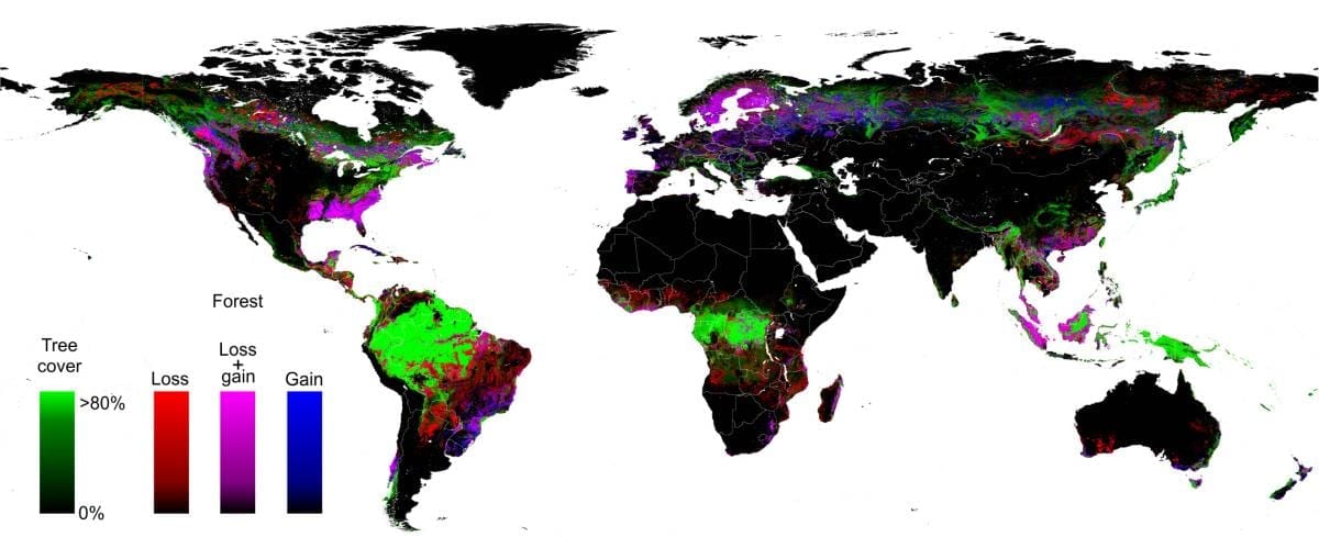
A University of Maryland-led, multi-organizational team has created the first high-resolution global map of forest extent, loss and gain.
This free resource greatly improves the ability to understand human and naturally-induced forest changes and the local to global implications of these changes on environmental, economic and other natural and societal systems, members of the team say.
In a new study, the team of 15 university, Google and government researchers reports a global loss of 2.3 million square kilometers (888,000 square miles) of forest between 2000 and 2012 and a gain of 800,000 square kilometers (309,000 square miles) of new forest.
Their study, published online on November 14 in the journal Science, documents the new database, including a number of key findings on global forest change. For example, the tropics were the only climate domain to exhibit a trend, with forest loss increasing by 2,101 square kilometers (811 square miles) per year. Brazil’s well-documented reduction in deforestation during the last decade was more than offset by increasing forest loss in Indonesia, Malaysia, Paraguay, Bolivia, Zambia, Angola and elsewhere.
“This is the first map of forest change that is globally consistent and locally relevant,” says University of Maryland Professor of Geographical Sciences Matthew Hansen, team leader and corresponding author on the Science paper.
“Losses or gains in forest cover shape many important aspects of an ecosystem, including climate regulation, carbon storage, biodiversity and water supplies, but until now there has not been a way to get detailed, accurate, satellite-based and readily available data on forest cover change from local to global scales,” Hansen says.
To build this first of its kind forest mapping resource, Hansen, UMD Research Associate Professor Peter Potapov and five other UMD geographical science researchers drew on the decades-long UMD experience in the use of satellite data to measure changes in forest and other types of land cover. Landsat 7 data from 1999 through 2012 were obtained from a freely available archive at the United States Geological Survey’s center for Earth Resources Observation and Science (EROS). More than 650,000 Landsat images were processed to derive the final characterization of forest extent and change.
The analysis was made possible through collaboration with colleagues from Google Earth Engine, who implemented the models developed at UMD for characterizing the Landsat data sets. Google Earth Engine is a massively parallel technology for high-performance processing of geospatial data and houses a copy of the entire Landsat image catalog. What would have taken a single computer 15 years to perform was completed in a matter of days using Google Earth Engine computing.
Hansen and his coauthors say their mapping tool greatly improves upon existing knowledge of global forest cover by providing fine resolution (30 meter) maps that accurately and consistently quantify annual loss or gain of forest over more than a decade. This mapping database, which will be updated annually, quantifies all forest stand-replacement disturbances, whether due to logging, fire, disease or storms. And they say it is based on repeatable definitions and measurements while previous efforts at national and global assessments of forest cover have been largely dependent on countries’ self-reported estimates based on widely varying definitions and measures of forest loss and gain.
Go deeper with Bing News on:
Global forest cover
- Nottingham Forest vs Manchester City: Where and How to Watch Live 2023/2024 Premier League Matchday 35
Nottingham Forest play against Manchester City for the Matchday 35 of the 2023/2024 Premier League. You can find out here how to watch this game on TV or live stream it in your country.
- They turned cattle ranches into tropical forest — then climate change hit
They brought forests back to life in Costa Rica. Their next challenge? Restoring ecosystems in a warming world.
- Dollar Wrecking Ball Forces Investors to Seek Cover in Exporters
The surging dollar has hurt stocks outside the US but one group at least stands to gain: companies that export to the world’s largest economy.Most Read from BloombergBiden’s Gains Against Trump Vanish ...
- Planting Trees In Grasslands Won't Save The Planet Rather Protect And Restore Forests
Tree planting is one of the nature-based solutions being used to offset greenhouse gas emissions. Trees absorb atmospheric carbon dioxide. Many of t ...
- Ecosystem ‘tipping points’ poised to severely harm global economy, study warns
Policymakers should recognise and properly assess the economic risks posed by ecosystem ‘tipping points’ (ETPs) in order to preserve global financial stability, according to r ...
Go deeper with Google Headlines on:
Global forest cover
[google_news title=”” keyword=”global forest cover” num_posts=”5″ blurb_length=”0″ show_thumb=”left”]
Go deeper with Bing News on:
Map of Global Forest Change
- A map of the world's forests to support the EU Regulation on Deforestation-free Supply Chains
The EU Joint Research Centre recently published an open-access global map of forest cover. CIRAD contributed to the map, which provides an explicit representation of forest presence that will serve to ...
- Researchers develop forest extent map for Mexico
To properly protect forests and evaluate the state of natural resources, conservation practices and environmental policies, it is important to have accurate information on an area's forest extent.
- How to see Climate Change images on Google Earth (2024)
In the Timelapse section of Google Earth you can find numerous aerial photographs showing how various landscapes of our Planet have changed over the past years. Here's how to watch our planet's ...
- Why no one knows exactly how much old-growth forest we have left
This statement, say critics, is especially true of the maps created by the U.S. Forest Service to inventory the nation’s largest carbon sinks: its mature and old growth forests. In April 2023, under ...
- Global Forest Wildfire Detection System Market to Touch Valuation of USD 1,259.81 Million By 2032, at 6.30% CAGR: Astute Analytica
New Delhi, April 09, 2024 (GLOBE NEWSWIRE) -- As per the report published by Astute Analytica, the global forest wildfire detection ... massively to climate change; they release stored carbon ...
Go deeper with Google Headlines on:
Map of Global Forest Change
[google_news title=”” keyword=”Map of Global Forest Change” num_posts=”5″ blurb_length=”0″ show_thumb=”left”]

