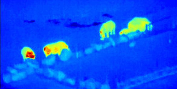
The world’s first astrophysics-ecology drone project at Liverpool John Moores University could be the answer to many global conservation efforts.
Four hundred years ago Galileo created a revolution by pointing his telescope to the skies. Now an astrophysicist and an ecologist from Liverpool John Moores University (LJMU) are reversing this perspective to help endangered species including rhinos and orang-utans.
The authors of the study, published in the International Journal of Remote Sensing, have brought together their expertise using drones, thermal cameras and the techniques used to analyse objects in space to find a solution to this 21st Century challenge for Earth.
Professor Serge Wich, from LJMU’s School of Natural Sciences and Psychology and the University of Amsterdam’s Institute for Biodiversity and Ecosystem Dynamics, is a pioneer in using drones for conservation work and is the founder of conservationdrones.org, commented:
“As an ‘eye in the sky’, conservation drones are helping the fight against illegal deforesting, poaching and habitat destruction, all leading to many species being endangered, including rhinos, orang-utans, and elephants. Now, teamed with the same astrophysics analysis techniques used to find and identify objects in the far-distant Universe, we can try to do this more efficiently.”
“The World Bank estimates that ecosystems provide $33 trillion every year to the global economy and biodiversity loss and consequent ecosystem collapse is one of the ten foremost dangers facing humanity. We hope this research will help tackle these problems by allowing anyone in the world to upload their aerial data and in real time get back geo-locations of anything, whether that be survivors of natural disasters, or poachers approaching endangered species, or even the size, weight and health of livestock.”
Dr Steve Longmore, from the LJMU Astrophysics Research Institute, explains why this is possible:
“Astrophysicists have been using thermal cameras for many decades. Crucially, it turns out the techniques we’ve developed to find and characterise the faintest objects in the Universe are exactly those needed to find and identify objects in thermal images taken with drones. The key to success is building libraries of the thermal heat profiles that act like “thermal finger prints”, allowing us to uniquely identify any animals detected. Our goal is to build the definitive finger print libraries and automated pipeline that all future efforts will rely upon.”
The next stage of this research, which will be funded by the Science and Technology Facilities Council (STFC), is to start expanding these techniques to other equally significant applications, including disaster relief and search and rescue.
This new drone technology is part of the growing technological innovation within LJMU. The Astrophysics Research Institute is also developing the world’s largest fully robotic telescope, a scaled up version of the Liverpool Telescope, located at the Roque de Los Muchachos Observatory, on the island of La Palma, and operated by LJMU as a national facility.
Learn more: The solution from the skies to save endangered species
[osd_subscribe categories=’drones’ placeholder=’Email Address’ button_text=’Subscribe Now for any new posts on the topic “DRONES”‘]
Receive an email update when we add a new DRONES article.
The Latest on: Astrophysics-ecology drone project
[google_news title=”” keyword=”astrophysics-ecology drone project” num_posts=”10″ blurb_length=”0″ show_thumb=”left”]
via Google News
The Latest on: Astrophysics-ecology drone project
- Assassin’s Creed Shadows: 40 Details You Need To Knowon May 15, 2024 at 10:49 am
Assassin’s Creed Shadows takes place in the Azuchi-Momoyama period of Japanese history. The story begins in 1579 and will continue into the early 1580s. The time period means this is the first game in ...
- Drones to monitor rural projectson May 11, 2024 at 5:00 pm
KANGAR: Drone technology or unmanned aerial vehicles will be used to monitor development projects by the Rural Development Ministry, said minister Datuk Seri Rina Mohd Harun. “For a start ...
- Top secret Iranian drone site used by IRGC, terror proxies exposed by opposition groupon May 11, 2024 at 1:00 am
The MEK also cites "intelligence sources" claiming that Supreme Leader of Iran Ali Khamenei "has personally overseen Iran’s drone project since 2004." The MEK urges other Western states to follo ...
- Class 12 Physics Project Ideas for Summer Vacation (2024)on May 10, 2024 at 1:17 pm
Physics Project Topics and Ideas for Class 12: Summer Vacations are about to begin and a long list of homework to be completed is coming along your way. Generally, teachers focus on making the ...
- HoloGW Project: Tackling Unresolved Mysteries in Astrophysics and Cosmologyon April 13, 2024 at 4:27 am
The HoloGW project has been granted funding of 2.5 million euros to tackle unresolved issues in cosmology and astrophysics from a new perspective. Image Credit: Lia Koltyrina/Shutterstock.com ...
- ESP-Drone: Building An ESP32-Based Quadcopter For Not Much Cashon March 31, 2024 at 4:11 am
What’s the cheapest quadcopter you can build? As [Circuit Digest] demonstrates with their variant of the ESP-Drone project by Espressif, you only need a minimum of parts: an ESP32 MCU ...
- How Construction Drones Can Benefit a Projecton September 27, 2023 at 11:43 pm
This article will explain how construction drones can benefit a project. Construction drones are unmanned aerial vehicles (UAVs) that can fly around a project site, taking pictures and video ...
- The Drone Paperson June 8, 2023 at 4:13 am
The documents, provided by a whistleblower, offer an unprecedented glimpse into Obama’s drone wars. The whistleblower who leaked the drone papers believes the public is entitled to know how ...
- Lanai drone project to continue without 5Gon July 17, 2019 at 5:00 pm
Flight operation plans on Lanai for a drone as wide as a football field are still on; however, the project will continue without testing for 5G advanced wireless airborne services to people on the ...
via Bing News


