


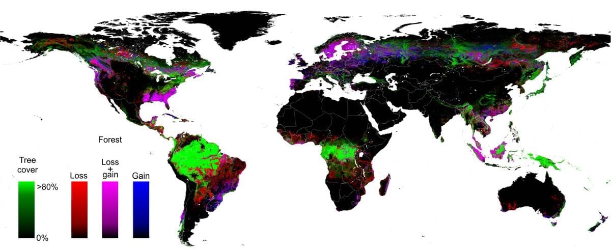
A University of Maryland-led, multi-organizational team has created the first high-resolution global map of forest extent, loss and gain.
This free resource greatly improves the ability to understand human and naturally-induced forest changes and the local to global implications of these changes on environmental, economic and other natural and societal systems, members of the team say.
In a new study, the team of 15 university, Google and government researchers reports a global loss of 2.3 million square kilometers (888,000 square miles) of forest between 2000 and 2012 and a gain of 800,000 square kilometers (309,000 square miles) of new forest.
Their study, published online on November 14 in the journal Science, documents the new database, including a number of key findings on global forest change. For example, the tropics were the only climate domain to exhibit a trend, with forest loss increasing by 2,101 square kilometers (811 square miles) per year. Brazil’s well-documented reduction in deforestation during the last decade was more than offset by increasing forest loss in Indonesia, Malaysia, Paraguay, Bolivia, Zambia, Angola and elsewhere.
“This is the first map of forest change that is globally consistent and locally relevant,” says University of Maryland Professor of Geographical Sciences Matthew Hansen, team leader and corresponding author on the Science paper.
“Losses or gains in forest cover shape many important aspects of an ecosystem, including climate regulation, carbon storage, biodiversity and water supplies, but until now there has not been a way to get detailed, accurate, satellite-based and readily available data on forest cover change from local to global scales,” Hansen says.
To build this first of its kind forest mapping resource, Hansen, UMD Research Associate Professor Peter Potapov and five other UMD geographical science researchers drew on the decades-long UMD experience in the use of satellite data to measure changes in forest and other types of land cover. Landsat 7 data from 1999 through 2012 were obtained from a freely available archive at the United States Geological Survey’s center for Earth Resources Observation and Science (EROS). More than 650,000 Landsat images were processed to derive the final characterization of forest extent and change.
The analysis was made possible through collaboration with colleagues from Google Earth Engine, who implemented the models developed at UMD for characterizing the Landsat data sets. Google Earth Engine is a massively parallel technology for high-performance processing of geospatial data and houses a copy of the entire Landsat image catalog. What would have taken a single computer 15 years to perform was completed in a matter of days using Google Earth Engine computing.
Hansen and his coauthors say their mapping tool greatly improves upon existing knowledge of global forest cover by providing fine resolution (30 meter) maps that accurately and consistently quantify annual loss or gain of forest over more than a decade. This mapping database, which will be updated annually, quantifies all forest stand-replacement disturbances, whether due to logging, fire, disease or storms. And they say it is based on repeatable definitions and measurements while previous efforts at national and global assessments of forest cover have been largely dependent on countries’ self-reported estimates based on widely varying definitions and measures of forest loss and gain.

Go deeper with Bing News on:
Global forest cover
- 38,100 Hectares Of Tree Cover Lost To Forest Fires
Since 2001, India has witnessed the loss of 38,100 hectares of tree cover to forest fires. The highest loss of tree cover was recorded in 2008, when overall 3 million hectares were gone as a result of ...
- ‘75% of country’s tree cover loss in 22 yrs happened in NE’
Guwahati: The tree cover loss in the northeast region during 2001-23 is over 75% of the country’s total tree cover decimation during the period, according to the data of the Global Forest Watch (GFW), ...
- Urgent need to halt deforestation, check further land degradation by 2030: UN forum on forests
India shared the launch of its Green Credit Programme that provides incentives to entities to take up tree plantation and restoration of degraded forests ...
- India ranks third globally in forest area gain from 2010-20
Showcasing its achievements in increasing forest cover over the past fifteen years, India informed the United Nations Forum on Forests (UNFF) that it ranks third globally in net gain in average ...
- At UNFF 19, India showcases its sustainable forest management success, expansion of protected areas
New Delhi: India highlighted its “significant advancements” in conservation and sustainable forest management at the 19th edition of the United Nations Forum on Forests (UNFF 19) in New York, noting a ...
Go deeper with Google Headlines on:
Global forest cover
[google_news title=”” keyword=”global forest cover” num_posts=”5″ blurb_length=”0″ show_thumb=”left”]
Go deeper with Bing News on:
Map of Global Forest Change
- From Ancient Charcoal, Hints of Wildfires to Come
By digging into the geologic record, scientists are learning how wildfires shaped — and were shaped by — climate change long ago.
- Seeing the Trees for the Forest
A bioregionalist sees a place as defined by both its natural and its human story: its history as told through soils, landforms (mountains, valleys, plain, prairie, forest, desert), watersheds, native ...
- How AI could become an unlikely ally in the fight against forest fires
A woman watches as wildfires tear through a forest in Chefchaouen, northern Morocco ... and quickly relay this information onto a map for the firefighters. Dozens of burnt-out vehicles in the ...
- AI model maps global tree canopy heights in hi-res, with carbon counting in mind
By Abhishyant Kidangoor More than one-third of land on Earth — that’s about three times the size of Russia, the largest country — has vegetation whose canopy reaches a height greater than 1 meter, or ...
- Maps developed with artificial intelligence confirm low levels of phosphorus in Amazonian soil
As the impacts of climate change increasingly affect the daily lives of residents in several countries, including Brazil, the resilience of forests, especially tropical ones such as the Amazon, has ...
Go deeper with Google Headlines on:
Map of Global Forest Change
[google_news title=”” keyword=”Map of Global Forest Change” num_posts=”5″ blurb_length=”0″ show_thumb=”left”]

