


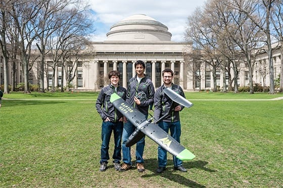
Crop analytics drone company Raptor Maps took the $100,000 grand prize May 13 at the 25th annual MIT $100K Entrepreneurship Competition.
The team of three MIT aerospace engineers developed an analytics platform that employs unmanned aircraft to pinpoint crop damage, target pesticide use, and increase yields.
For some startups, a $100,000 prize and the cache of winning a top business plan contest can boost an idea toward acquiring capital to get up and running. For Raptor Maps, the low cost of the drones means the prize money can equip the company to begin serving paying clients almost immediately.
“The money will go to building the analytics platform for scale operations,” said Nikhil Vadhavkar, executive at Raptor Maps, and a PhD student in the Harvard-MIT Division of Health Sciences and Technology. “We can get three or four aircraft and establish a beachhead in the market. Because we can build so cheaply, this is exactly the boost we need.”
Raptor Maps was born far from the agricultural fields it seeks to serve. Team members were part of a NASA geological field mission last summer and determined that satellite imagery was “not cutting it. Drones can do it better,” said Vadhavkar. Satellites are too far away, he said, and the current dominant method of crop evaluation—walking—is too close to cover more than a small portion of acreage in a day.
Raptor Maps’ drones strike a useful middle ground. They can survey entire farms with high-resolution imagery, use proprietary analytics to pinpoint problem areas, such as infestations, and target chemical applications. The team hopes to increase yields in an industry anxious to both decrease chemical use due to environmental concerns and save more of the estimated one-third of crops that are lost each year to bugs and disease.
Read more: Raptor Maps wins 25th annual MIT $100K with drone crop monitoring
The Latest on: Crop evaluation drones
[google_news title=”” keyword=”Crop evaluation drones” num_posts=”10″ blurb_length=”0″ show_thumb=”left”]
via Google News
The Latest on: Crop evaluation drones
- Holguín uses drones for economic and social developmenton April 25, 2024 at 8:19 pm
Use of drones for the benefit of economy and society is increasing throughout Cuba, particularly in eastern areas, such as Holguin province.
- Drones and AI in the battle against Alternaria in potato cropson April 22, 2024 at 5:02 am
By employing ultra-high-resolution drone imagery combined with AI, a new method has been developed for the early detection of Alternaria.
- Safety Initiatives To Maximize Efficacy And Well-being For Aerial Applicationon April 18, 2024 at 5:00 pm
Before a farmer or landowner considers leasing land for the construction of wind turbines, meteorological evaluation towers or broadband towers ... fertilizers and seeds that is unobtrusive to the ...
- March 2024 robotics investments total $642Mon April 18, 2024 at 7:14 am
March 2024 robotics funding, spread among 37 companies, was buoyed by significant investment into software suppliers.
- Bangladesh to introduce drone tech to assess crop losses: ADBon April 17, 2024 at 7:57 am
Bangladesh is preparing to introduce remote sensing and drones to detect crop damage caused by extreme weather events or diseases, said the Asian Development ...
- 4-day NAP Expo to begin on April 22: Saberon April 17, 2024 at 6:34 am
Environment, Forest and Climate Change Minister Saber Hossain Chowdhury today said UN Climate Adaptation Conference National Adaptation Plan (NAP) Expo 2024 will be held at Bangabandhu International ...
- Bangladesh to introduce drone technology to assess crop losseson April 17, 2024 at 4:10 am
Bangladesh is preparing to introduce remote sensing and drones to detect crop damage caused by extreme weather events or diseases, said the Asian Development Bank (ADB).Around 20 officers of the ...
- Bangladesh to introduce drone technology to assess crop losses: ADBon April 17, 2024 at 3:38 am
Malay Choudhury, additional secretary, Ministry of Agriculture, and Edimon Ginting, ADB country director for Bangladesh inaugurated a workshop titled "The Use of Drone and Satellite Image for Crop ...
- Agricultural Sprayers Market Segmentation Analysis, Share, Trends, Size, Key Players, and Forecast to 2024 to 2032on April 16, 2024 at 4:37 pm
Report Ocean recently published a research report titled “Agricultural Sprayers Market” 2024 Forecast to 2032 Analysis by Market Trends.” This study delivers accurate economic projections, worldwide ...
- Commercial Unmanned Aerial Systems (UAS) Market Size, Latest Trends, Share, Key Players, Revenue, Opportunity, and Forecast 2024 to 2032on April 16, 2024 at 3:38 pm
Report Ocean recently published a research report titled “Commercial Unmanned Aerial Systems (UAS) Market” 2024 Forecast to 2032 Analysis by Market Trends.” This study delivers accurate economic ...
via Bing News
