- Image via Wikipedia
THE GLOBAL DIGITAL SOIL MAP WILL GENERATE DATA CRUCIAL FOR COMBATING HUNGER, POVERTY, AND CLIMATE CHANGE.
Soil is a critical component of our planet’s ecosystems—it provides food, animal feed, textiles, and wood products for our use. Soil also filters much of our waste and regulates climate, water, and nutrient cycles essential to our ecology. While revered by early philosophers as one of the four elements (earth, fire, water and air), it is often demeaned as dirt—technically, soil where it doesn’t belong. People are increasingly aware, however, that mismanagement of soils can lead to food shortages, erosion, increased greenhouse gas emissions, and decreased water quality. As populations continue to grow, so will pressure on our natural resources to provide even more ecosystem services. Soil is outgrowing its traditional connection to agriculture, taking its place in a much broader understanding of ecosystems. As such, humanity must understand and protect this critical resource. But how?
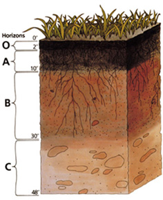
Soil science began when V.V. Dokuchaev first separated soils from geology in 1883. Some 40 years earlier, Justus von Liebig’s discovery of essential plant nutrients foreshadowed this division. Today there are more than 16,000 soil scientists worldwide who stand on the foundations of Dokuchaev and von Liebig. They range from pedologists, who study, map, and classify soils as natural bodies, to edaphologists who study soils for the agricultural, urban, ecological, and environmental services they provide to humankind. Pedologists have traditionally focused on long-term dynamic soil properties such as the rate of soil formation in a layer of bedrock, while edaphologists (which include agronomists, biogeochemists, civil engineers, among others) often have a detailed understanding of short-term soil dynamics and land use.
Many of these soil scientists have turned their attention to the problem of fertile soils, which are key for growing enough food to feed global populations. One billion people in the world are currently hungry and undernourished, and in sub-Saharan Africa, where many of these 1 billion live, food insecurity is directly related to the depletion of soil fertility: Nitrogen, essential for protein formation, and phosphorus, a vital nutrient for plant photosynthesis and energy transport, are now particularly low in their soils because farmers have extracted them without restoring them through fertilizer use. As a result, the average African farm produces one ton of corn per hectare, while in the US and Europe, the average is 8 tons. Many scientists are also studying soil in the context of climate change. Agriculture is responsible for about one-third of our greenhouse gas emissions to the atmosphere, and much of this is soil-related. Carbon dioxide from deforestation and respiration of soil microorganisms; methane from wet soils, rice fields, and cattle belches; and nitrous oxide from both mineral and organic fertilizers all play a role.
But communicating soil’s information to diverse audiences remains challenging because of technical jargon and antiquated methods. Soil maps exist for many areas of the world but are static and often the legends are displayed in ways that are indecipherable to most laypersons, making it difficult for government officials to use the soil information to guide their policy decisions.
Digital soil maps, and the information systems derived from them, will help solve these problems. Based on new methodologies that make soil information understandable to non-experts, the maps provide more precise information that will capture the complexity and dynamic nature of soil. An international consortium of scientists is now collaborating on an innovative project to produce a digital soil map of the world. Known as GlobalSoilMap.net, it will house crucial information for a range of issues facing our planet, such as food security, climate change, and water use, in pixels at 90-meter resolution—about 0.8 hectares or two acres.


