


The wave-powered sub Papa Mau not only set a record while crossing the Pacific Ocean autonomously, it also studied rogue waves and other marine phenomena invisible to eyes in the sky
When the robotic Papa Mau completed its 16,668-kilometer scientific expedition across the Pacific Ocean last month, the surfboard-sized submarine did more than set a new world record for the longest distance traveled by an autonomous vehicle. The wave-powered sub reached Australia’s Hervey Bay with a load of data that will keep marine biologists, oceanographers and other scientists busy for quite some time, including observations of rogue waves that satellites failed to detect during the Papa Mau’s year-long voyage.
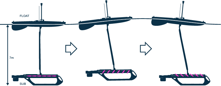
On what appeared to be a calm, sunny day last February, Papa Mau transmitted data indicating rough weather—six- to 7.6-meter rolling seas and winds blowing at 50 knots. The sub had been at sea since November 17, 2011, the first of a fleet of four robot subs (called Wave Gliders) launched from San Francisco Bay by Liquid Robotics, Inc.
“There was not a cloud in the sky, nothing was on the satellites,” says Bill Vass, CEO of Sunnyvale, Calif.-based Liquid Robotics, a provider of ocean data services for shipping, energy and environmental companies. “And we said, ‘Oh, there must be something wrong with [the submarine’s] sensors.’ But when all four robots saw [the waves], we turned on the cameras. It was pretty astounding.” Nearby, an unfortunate sailboat lost its mast and was rescued by a Dutch freighter. “Besides that sailboat, the freighter, and us, no one would have seen those waves,” Vass adds.
Maritime history is filled with fantastical stories of rogue waves that appear suddenly, like walls of water, to swamp unsuspecting sailors and their vessels. As recently as 2010, several such monstrous waves hit the cruise ship Louis Majesty in the Mediterranean off the coast of Spain, an incident that killed two people and injured six.
Satellites in the worldwide communications system used for transmitting data from offshore locations “make their best guess” from 400 kilometers up about weather conditions at sea, including wind speeds and wave heights, according to Vass. They not only miss giant waves but are “tremendously inaccurate” in estimating the speeds of current and wave direction, he says
After comparing satellite data with his robots’ findings, Vass believes satellites detect surface shear, which comes from winds and broad currents. There are two dimensions to surface shear. One is the difference in currents at the ocean’s surface compared with those flowing at lower levels of the water column. The second occurs when two currents collide and generate smaller localized eddies and turbulence. Both are important to know when determining circulation and its effect on shipping energy usage and fuel consumption.
“We’re finding the satellites are way off for microcurrents,” Vass says. “In many cases, the satellite models were showing currents 180 degrees off from the currents we actually experienced, and off by a factor of two to three in speed. Our robots feel the first eight meters of ocean.” A drifter—a buoy that may submerge to a depth, then rise to the surface while tracking the path of a current—might detect a surface current, and a satellite might “see” the first few inches of the ocean, but Vass says his robot gliders “feel the full breadth of the current.” As such, the gliders ran through a series of eddies that were invisible to the satellites. They also crossed the equator where, according to satellite models, a huge shear current was thought to run east to west. Yet the flotilla experienced none of that. Upwellings, rising masses of water that can be small or enormous and that often carry deep ocean nutrients to the surface, were also in the wrong places compared to what the satellites indicated, he adds.
“The speed and directions of currents have major effects on the shipping industry, oil and gas and marine operations, as well as global weather,” Vass says. “The robot gliders’ ability to show measurements will change the way many of these industries work in the future.”
Read more . . .
via Scientific American – Karen A. Frenkel
The Latest Streaming News: Autonomous ocean vehicle updated minute-by-minute
Bookmark this page and come back often
Latest NEWS
Latest VIDEO