via University of Leicester
New satellite imaging concept proposed by University of Leicester-led team could significantly reduce search areas for missing boats and planes
- Concept uses satellite technology already in orbit to take images of sea
- Enables ship and plane movement to be pinpointed to much more accuracy
- Data can be used when vessels are lost at sea to minimise search area and speed up search and rescue time
- Could have been used to aid search for missing Malaysian flight MH370
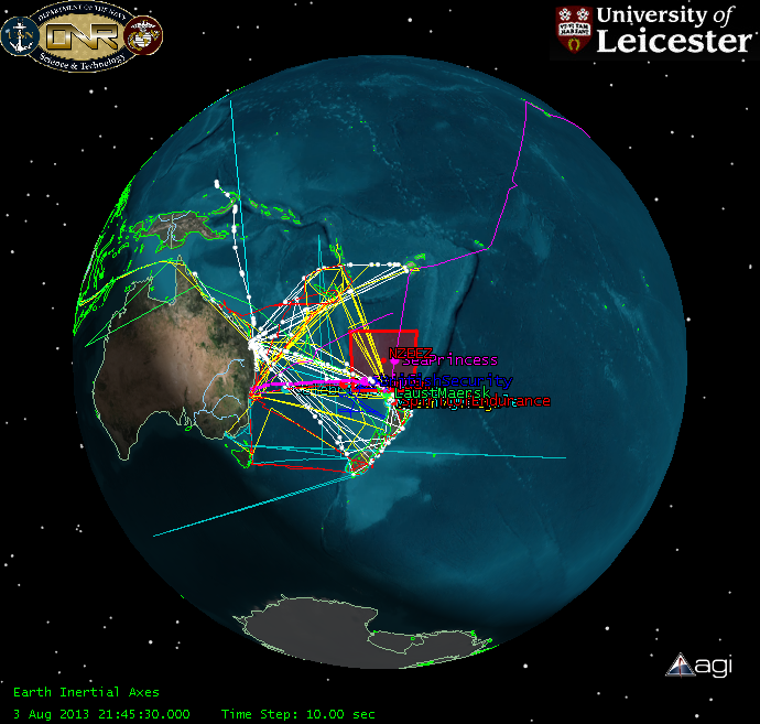
A space scientist at the University of Leicester, in collaboration with the New Zealand Defence Technology Agency and DMC International Imaging, has been trialling a concept for using satellite imagery to significantly improve the chances of locating ships and planes, such as the missing Malaysian flight MH370, lost at sea.
A preliminary study published this month in the International Journal of Remote Sensing, identified 54 satellites with 85 sensors, currently only taking images of land, which could be used to take images of the Earth’s oceans and inland waters.
The research team believe regularly updated images of the seas via these satellites could enable the reduction of search areas for missing ships to just a few hundred square miles. This offers the possibility of dramatically reducing search and rescue times and significantly improving chances of survival for missing ships.
Dr Nigel Bannister from the University’s department of Physics and Astronomy explained: “If you are in the open ocean, and you get into difficulty, particularly in a small vessel, there is a significant chance that you will be lost at sea. There is currently a big problem tracking small vessel maritime traffic and this system could provide a much improved awareness of vessel movements across the globe, using technology that already exists.
“This isn’t a surveillance system that monitors vessel movements across the oceans in real time, like radar tracking of aircraft in the sky; instead we have proposed a system which records images every time a satellite passes over specific points of the sea. If we are alerted to a lost vessel, the images allow us to pinpoint its last observed position. This could be very powerful for constraining search areas and it could reduce the time it takes to locate missing boats and planes, and hopefully their crews and passengers.”
David Neyland, former Assistant Director of the US Navy Office of Naval Research-Global, who funded the research, added: “The University of Leicester brought to this research a unique capability to build a public, open source model, of an International Virtual Constellation of spacecraft from 19 nations – a transparent view of space operations never done before.
Read more: Scientists trial system to improve safety at sea
The Latest on: Satellite imaging
[google_news title=”” keyword=”Satellite imaging” num_posts=”10″ blurb_length=”0″ show_thumb=”left”]
via Google News
The Latest on: Satellite imaging
- Satellite images overlay 2024 and 2017 total solar eclipses sweeping across USon April 26, 2024 at 3:00 am
North America has experienced two transcontinental total solar eclipses within the last seven years, and these satellite images compare the crisscrossing paths of totality.
- Stunning satellite images show just how big Death Valley’s lake really was. See themon April 25, 2024 at 2:07 pm
The images show the rare lake in the middle of the desert in California was deeper than previously thought, which might explain its staying power.
- China harbours ship transporting North Korean munitions to Russia, satellite images showon April 25, 2024 at 5:46 am
China is providing moorage for a US-sanctioned Russian cargo ship implicated in North Korean arms transfers to Russia, according to satellite images.
- Exclusive-China harbors ship tied to North Korea-Russia arms transfers, satellite images showon April 24, 2024 at 10:39 pm
China is providing moorage for a U.S.-sanctioned Russian cargo ship implicated in North Korean arms transfers to Russia, according to satellite images obtained by Reuters, as U.S. concerns grow over ...
- Downloading Satellite Imagery With A Wi-Fi Antennaon April 24, 2024 at 4:01 pm
Over the past century or so we’ve come up with some clever ways of manipulating photons to do all kinds of interesting things. From lighting to televisions and computer screens to ...
- Satellite images show devastation at oil production facilities in Russia's Smolensk Oblast after drone attackon April 24, 2024 at 4:20 am
Satellites recorded a great fire near the oil depot near Rozdorove in Russia's Smolensk Oblast, revealing likely two strike points, the Krymskyi Veter (Crimean Wind) Telegram channel reported on April ...
- Satellite Images Capture Extraordinary Flooding in the United Arab Emirateson April 24, 2024 at 1:55 am
A powerful storm system battered major cities in the Arabian Peninsula. This slow-moving storm system brought extraordinary rainfall to the UAE, causing widespread flooding, disrupting transport, and ...
- Ships smuggling Russian oil spotted in satellite images by AIon April 23, 2024 at 8:17 am
AI can analyse satellite images to reveal the movements of dark ships in a shadow fleet that smuggles oil and other cargo from sanctioned countries such as Russia, Iran, Venezuela and North Korea ...
- Celebrating Earth Day: The first satellite images of the earth were taken 64 years agoon April 23, 2024 at 1:27 am
TIROS 1 was launched into space on April 1, 1960, from Cape Canaveral. Equipped with two cameras, the first weather satellite transmitted the grainy black-and-white footage back to Earth. According to ...
- Earth Day 2024: Witness our changing planet in 12 incredible satellite imageson April 22, 2024 at 11:30 am
Happy Earth Day 2024! Every year on April 22, we celebrate Earth Day. This annual event is a time to focus on the environmental issues we have across the planet and highlight the efforts being made so ...
via Bing News


