


Mobile LIDAR may someday be a key to driverless automobiles
Imagine driving down a road a few times and obtaining in an hour more data about the surrounding landscape than a crew of surveyors could obtain in months.
Such is the potential of mobile LIDAR, a powerful technology that’s only a few years old and promises to change the way we see, study and record the world around us. It will be applied in transportation, hydrology, forestry, virtual tourism and construction – and almost no one knows anything about it.
That may change with a new report on the uses and current technology of mobile LIDAR, which has just been completed and presented to the Transportation Research Board of the National Academy of Sciences. It will help more managers and experts understand, use and take advantage of this science.
The full exploitation of this remarkable technology, however, faces constraints. Too few experts are trained to use it, too few educational programs exist to teach it, mountains of data are produced that can swamp the computer capabilities of even large agencies, and lack of a consistent data management protocol clogs the sharing of information between systems.
“A lot of people and professionals still don’t even know what mobile LIDAR is or what it can do,” said Michael Olsen, an assistant professor of civil engineering at Oregon State University, and lead author of the new report. “And the technology is changing so fast it’s hard for anyone, even the experts, to keep up.
“When we get more people using mobile LIDAR and we work through some of the obstacles, it’s going to reduce costs, improve efficiency, change many professions and even help save lives,” Olsen said.
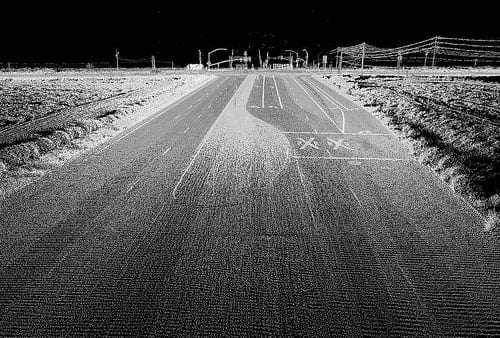
LIDAR, which stands for light detecting and ranging, has been used for 20 years, primarily in aerial mapping. Pulses of light up to one million times a second bounce back from whatever they hit, forming a highly detailed and precise map of the landscape. But mobile LIDAR used on the ground, with even more powerful computer systems, is still in its infancy and has only been commercially available for five years.
Mobile LIDAR, compared to its aerial counterpart, can provide 10 to 100 times more data points that hugely improve the resolution of an image. Moving even at highway speeds, a technician can obtain a remarkable, three-dimensional view of the nearby terrain.
Such technology could be used repeatedly in one area and give engineers a virtual picture of an unstable, slow-moving hillside. It could provide a detailed image of a forest, or an urban setting, or a near-perfect recording of surrounding geology. An image of a tangle of utility lines in a ditch, made just before they were backfilled and covered, would give construction workers 30 years later a 3-D map to guide them as they repaired a leaking pipe.

Mobile LIDAR may someday be a key to driverless automobiles, or used to create amazing visual images that will enhance “virtual tourism” and let anyone, anywhere, actually see what an area looks like as if they were standing there. The applications in surveying and for transportation engineering are compelling, and may change entire professions.
Just recently, mobile LIDAR was used to help the space shuttle Endeavour maneuver through city streets to reach its final home in Los Angeles.
The Latest Bing News on:
LIDAR
- Evolution in PID solutions - Quanergy 3D LiDAR dominates security marketon May 2, 2024 at 2:05 am
Enhancing physical security, especially perimeter intrusion detection (PID) at critical infrastructure sites like airports, data centres, warehouses, and utilities, is increasingly crucial ...
- Seyond Collaborates with Curiosity Lab and Peachtree Corners to Deploy LiDAR Solution to Improve VRU Safety and Traffic Intersection Efficiencieson May 2, 2024 at 2:00 am
May 2, 2024 /PRNewswire/ -- Peachtree Corners – one of the United States' first 5G smart cities powered by real-world connected infrastructure – announced a collaboration with global provider of image ...
- KAIST accused of leniency to professor who leaked LIDAR tech to Chinaon May 2, 2024 at 12:05 am
The Korea Advanced Institute of Science and Technology (KAIST) is being criticized for hesitating to take disciplinary action against a professor found guilty of leaking autonomous vehicle ...
- Watch: Laser-Focused Logistics: The Value of LiDAR Technology in the Supply Chainon April 29, 2024 at 9:01 pm
LiDAR, a remote-sensing method using pulsed lasers to measure range, is proving to be of high value in supply chain automation, says Peipei Zhao, president of North America with Robosense.
- Scripps researchers are laser-focused on forecasting bluff failure along California's coaston April 27, 2024 at 6:55 pm
California’s coastline is constantly changing and a group of scientists at Scripps Institution of Oceanography is keeping a laser-focused eye on those changes thanks to some pretty advanced technology ...
- How Tiny Lidar Tech is Redefining High-Resolution 3D Mappingon April 25, 2024 at 7:00 am
Compact, low-power system opens doors for photon-efficient drone and satellite-based environmental monitoring and mapping. Researchers have developed a compact and lightweight single-photon airborne ...
- Lidar: Another emerging technology brought to you by Chinaon April 25, 2024 at 6:00 am
More must be done to safeguard U.S. data and prevent dependence on geopolitical adversaries for a critical, emerging technology.
- Scientists demonstrate high-resolution lidar sees birth zone of cloud droplets, a first-ever remote observationon April 24, 2024 at 9:45 am
A team led by atmospheric scientists at the U.S. Department of Energy's Brookhaven National Laboratory has demonstrated the first-ever remote observations of the fine-scale structure at the base of ...
- ‘World’s 1st’ flamethrower robot dog gets remote control and LiDARon April 24, 2024 at 3:51 am
The quadruped robot dog is now operated by a first-person view (FPV) controller, a concept that is increasingly gaining traction with the rise of drones.
- Luminar starts shipping lidar for Volvo EX90 — while readying its next-gen sensoron April 23, 2024 at 3:00 pm
The order of lidar sensors to Volvo, which Luminar notes is worth $4 billion, comes after Volvo announced last year that it had to push production start of the EX90 to early 2024. At the time, the ...
The Latest Google Headlines on:
LIDAR
[google_news title=”” keyword=”LIDAR ” num_posts=”10″ blurb_length=”0″ show_thumb=”left”] [/vc_column_text]The Latest Bing News on:
Mobile LIDAR
- Honor Magic 6 RSR Porsche Design review: absolute luxuryon May 2, 2024 at 2:45 am
It has a striking design and a hefty price tag, but does Honor’s latest Porsche Design smartphone offer enough to be worth the cost?
- Seyond Collaborates with Curiosity Lab and Peachtree Corners to Deploy LiDAR Solution to Improve VRU Safety and Traffic Intersection Efficiencieson May 2, 2024 at 2:00 am
About Seyond Seyond is a leading global provider of image-grade LiDAR technology, powering a safer, smarter and more mobile world across the automotive, intelligent transportation, robotics and ...
- Pix4D upgrades PIX4Dcatch with augmented reality featureson May 1, 2024 at 12:13 am
Pix4D, one of the leading providers of drone and terrestrial mapping and photogrammetry solutions, has launched PIX4Dcatch 2.0. This new and ...
- Details of hurricane Ian's aftermath captured with new remote sensing methodon April 29, 2024 at 11:48 am
Using aerial imagery data and LiDAR, a study remotely identified the hardest-hit areas of Southwest Florida's Estero Island in the aftermath of Hurricane Ian. Researchers estimated the extent of ...
- Flame-throwing robo-dog can now be yours for under $10kon April 25, 2024 at 5:41 am
A robo-dog capable of throwing 30-ft flames from its back might seem the stuff of sci-fi nightmares, but such terrors were made real last year with the launch of the Thermonator from Ohio's Throwflame ...
- Airborne single-photon lidar system achieves high-resolution 3D imagingon April 24, 2024 at 5:00 pm
The video shows 3D images acquired using the single-photon airborne lidar system aboard a small plane. Credit: Feihu Xu, University of Science and Technology of China In Optica the researchers ...
- Lidar: Another emerging technology brought to you by Chinaon April 24, 2024 at 5:00 pm
A Hesai-made lidar sensor sits on top of an autonomous vehicle on July 10, 2022, as it drives along a street in Shenzhen, China. (Jade Gao/AFP via Getty Images) The exponential growth in connected ...
- Scientists demonstrate high-resolution lidar sees birth zone of cloud droplets, a first-ever remote observationon April 23, 2024 at 5:00 pm
To see details within the cloud base, the Brookhaven team worked with colleagues at Stevens Institute of Technology (SIT) and Raymetrics S.A. to build a new kind of lidar. Their device ...
- Luminar unveils new compact lidar sensor Halo, tie-up with Applied Intuitionon April 23, 2024 at 11:03 am
Luminar Technologies launched its latest lidar sensor on Tuesday and said it has partnered with auto software maker Applied Intuition to aid automakers in testing their assisted-driving systems.
- Luminar Launches Production For Volvo And Shows Next-Gen Halo Lidaron April 23, 2024 at 11:00 am
The most important near term news though is that volume production of the Luminar Iris lidar has begun for its first global customer, Volvo. Production of the Iris for Volvo is crucially important ...
The Latest Google Headlines on:
Mobile LIDAR
[google_news title=”” keyword=”fix the internet” num_posts=”10″ blurb_length=”0″ show_thumb=”left”]
