


CREDIT
RMIT University
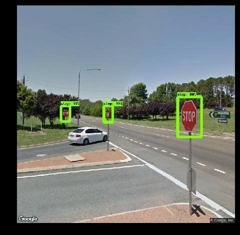
Geospatial scientists have developed a new program to monitor street signs needing replacement or repair by tapping into Google Street View images.
The fully-automated system is trained using AI-powered object detection to identify street signs in the freely available images.
Municipal authorities currently spend large amounts of time and money monitoring and recording the geolocation of traffic infrastructure manually, a task which also exposes workers to unnecessary traffic risks.
Results just published in the journal of Computers, Environment and Urban Systemsshow the system detects signs with near 96% accuracy, identifies their type with near 98% accuracy and can record their precise geolocation from the 2D images.
Study lead author and RMIT University Geospatial Science Honours student, Andrew Campbell, said the proof-of-concept model was trained to see ‘stop’ and ‘give way'(yield) signs, but could be trained to identify many other inputs and was easily scalable for use by local governments and traffic authorities.
“(Municipal authorities) have requirements to monitor this infrastructure but currently no cheap or efficient way to do so,” Campbell said.
“By using free and open source tools, we’ve now developed a fully automated system for doing that job, and doing it more accurately.”
The team found during investigations that mandatory GPS location data in existing street sign databases was often inaccurate, sometimes up to 10m off.
“Tracking these signs manually by people who may not be trained geoscientists introduces human error into the database. Our system, once set up, can be used by any spatial analyst – you just tell the system which area you want to monitor and it looks after it for you,” Campbell said.
Campbell credited the project’s initial concept to his industry mentor at Alpine Shire Council and RMIT Geospatial Science alumnus, Barrett Higman.
RMIT geospatial scientist and project co-lead, Dr Chayn Sun, said the fact that some councils were already attaching cameras onto rubbish trucks to gather street footage showed how valuable visual data were becoming, given what technology could now do with it.
“This imagery is critical for local governments in monitoring and managing assets and with the huge amount of geospatial applications flourishing, this information will only become more valuable,” Sun said.
“Ours is one of several early applications for this to meet a specific industry need but a whole lot more will emerge in coming years.”
Sun said footage from other sources, like that from rubbish truck cameras or any other geo-referenced imagery of the road network collected by municipal authorities, could also be fed into the system.
“Where footage is already being gathered, our research can provide councils with an economical tool to drive insights and data from this existing resource,” she said.
Learn more: New AI system manages road infrastructure via Google Street View
The Latest on: AI-powered object detection
[google_news title=”” keyword=”AI-powered object detection” num_posts=”10″ blurb_length=”0″ show_thumb=”left”]
via Google News
The Latest on: AI-powered object detection
- Intel: 500 AI models have been optimised for Core Ultra processorson May 1, 2024 at 4:43 pm
Intel said more than 500 AI models have been optimised for its Core Ultra processors, calling the move a “significant milestone” in its effort to position itself as the prime chip supplier for AI PCs.
- Intel: 500 AI Models Have Been Optimized For Core Ultra Processorson May 1, 2024 at 10:33 am
Intel said more than 500 AI models for its Core Ultra processors in an effort to cement itself as the AI PC chip leader.
- AI and Home Security: What To Knowon May 1, 2024 at 8:17 am
Learn about AI-powered security systems: standout features, possible downsides and differences from traditional systems.
- China's AI-Powered Satellites Imperil US Aircraft Carrierson April 30, 2024 at 8:13 pm
It comes equipped with synthetic aperture radar (SAR) and AI processors for rapid detection and identification of targets ... achieving a 95% precision rate in identifying small objects, seven times ...
- The impact of AI on edge computingon April 30, 2024 at 12:36 pm
AI at the edge offers real-time responsiveness, privacy compliance, and cost efficiency. Where are you on your edge journey?
- AI Revolutionizes the Future of Foodon April 25, 2024 at 9:11 pm
Artificial intelligence (AI) finds its way into almost every aspect of Americans’ lives. At the end of February, there was a minor scandal regarding fast food burger giant Wendy’s tests with ...
- Safe Pro AI Published in IEEE Spectrum Featuring SpotlightAI(TM) AI-Powered Land Mine Detection Technology in Ukraineon April 25, 2024 at 8:20 am
Article Features an Insider's Look at SpolightAI's Development and Highlights Progress of Ramping-up Operations in Support of Humanitarian Mine Action Efforts in Ukraine AVENTURA, FL / ACCESSWIRE / ...
- SimpliSafe Expands Live Guard Service With New Home AI Featureson April 23, 2024 at 1:16 pm
SimpliSafe is rolling out AI detection for friendly faces if you use its home monitoring. Here's exactly what to expect from the new service.
- Move over Ring – EZVIZ’s new security camera uses AI detection to recognise license plateson April 17, 2024 at 2:55 am
EZVIZ has launched its new EL3 smart security camera and wall light. With AI-powered detection, the camera can detect people, pets, vehicles and license plates. Its siren and spotlight system is also ...
- INFINIQ's AI Model Achieves Top Performance in Few-Shot Object Detectionon April 10, 2024 at 5:00 pm
The model leverages the power of image-language similarity to pinpoint object location ... shot object detection category on "papers with code," a renowned platform for sharing AI research ...
via Bing News
