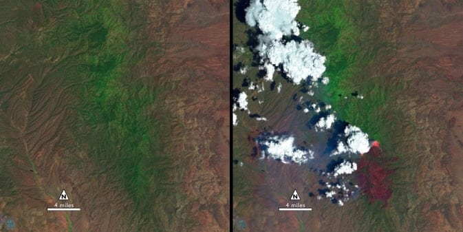
The “before” image (left) is a false-color Landsat 8 image acquired May 28, 2013. The “during” image was acquired, June 13, 2013, while the New Mexico Silver Fire was still growing. (The white puffs with black shadows in the right image are clouds.) Image Credit: USGS/NASA
While the 138,000-acre Silver Fire still smoldered, forest restoration specialists were on the job.
They analyzed maps created using Landsat satellite data to determine where the burn destroyed vegetation and exposed soil – and where to focus emergency restoration efforts.
“The map looked like a big red blob,” said Penny Luehring, the U.S. Forest Service’s Burned Area Emergency Response and watershed improvement program leader, based in Albuquerque, N.M.
Red means high-severity fire, she explained – and the red areas were concentrated in a watershed drainage that fed communities west of Las Cruces, N.M. So crews got to work. The Burned Area Emergency Response, or BAER, teams are designed to go in as soon as the flames die down to help protect reservoirs, watersheds and infrastructure from post-fire floods and erosion. And Landsat satellites, built by NASA and operated by the U.S. Geological Survey, help direct the crews to those forest areas needing attention.
As a wildfire starts to die down, fire managers like Luehring can contact the Forest Service’s Remote Sensing Applications Center in Salt Lake City to request maps that identify the high, moderate and low severity burns. When that call comes in, remote sensing specialist Carl Albury finds satellite imagery of the burned forest both pre- and post-fire.
In Landsat images, he looks at two of the 11 spectral bands – the near-infrared band and a short-wave infrared band.
“The near infrared reflects well from healthy vegetation, and the short-wave infrared bands reflect well from exposed ground,” Albury said. “By comparing the normalized ratio of the near- and shortwave-infrared bands in the pre-fire image to the post-fire image, we can estimate the burn severity.”
The near-infrared wavelength bounces off of healthy plant cells, and so sends back a strong signal to the Landsat detector that isn’t present over burned areas, explained Jeff Masek, Landsat program scientist with NASA’s Goddard Space Flight Center in Greenbelt, Md. But the shortwave infrared band – added to Landsat satellites starting with Landsat 4 – has a distinct spectral signature for burned areas.
“The char will show up very clearly in the shortwave,” Masek said.
Albury takes a ratio of the two spectral bands, both before and after a fire. Comparing those ratios, he creates a rough map of fire severity, called the Burned Area Reflectance Classification, or BARC. The BAER teams calibrate or adjust the maps based on on-the-ground observations, and then use them to plan time-sensitive restoration projects.
“Without the BARC product the only way for them to assess the fire is on foot or by helicopter,” Albury said, noting that doing so is often infeasible for large fires on remote terrain. “It gives them a sense for how much they need to do, and where they need to do it.”
While he also employs remote sensing data from other satellites, Landsat is the satellite of choice, Albury said. That’s because of the coverage of its spectral bands as well as the free availability of the images – he can sort through to find cloud-free views of that forest at a similar time in the growing season for the pre-fire comparison. And with Landsat 8 online this summer, the new images don’t have the gaps present in Landsat 7 imagery. Plus, having two satellites orbiting halves the wait time for post-fire images.
The Latest Bing News on:
Landsat
- UAE Announces $544M For Repairs After Record Rainson April 25, 2024 at 9:01 pm
DUBAI - The United Arab Emirates announced $544 million to repair the homes of Emirati families on Wednesday after last week's record rains caused w ...
- Oman, UAE deluge 'most likely' linked to climate change: scientistson April 25, 2024 at 9:00 am
Global warming caused by fossil fuel emissions "most likely" exacerbated the intense rains that lashed the UAE and Oman last week, causing deaths and widespread flooding, an expert group of ...
- Dubai Flooding Was Up to 40% More Intense Due to Climate Changeon April 25, 2024 at 8:00 am
Global warming exacerbated recent rain in the UAE and Oman, scientists found, although the rarity of such events makes it difficult to determine how much.
- Ash Shrouded Skies: Powerful Volcanic Eruption at Mount Ruangon April 24, 2024 at 9:05 am
A powerful volcanic eruption lofted ash high into the atmosphere and spread tephra and other volcanic debris across the small island in Indonesia. Ruang is a small volcanic island in the Sangihe ...
- Satellite Images Capture Extraordinary Flooding in the United Arab Emirateson April 24, 2024 at 1:55 am
A powerful storm system battered major cities in the Arabian Peninsula. This slow-moving storm system brought extraordinary rainfall to the UAE, causing widespread flooding, disrupting transport, and ...
- NASA releases satellite photos of Dubai and Abu Dhabi before and after record floodingon April 24, 2024 at 1:20 am
The deluge closed schools and businesses, grounded hundreds of flights, and destroyed cars, businesses and other property.
- NASA data helps beavers build back streamson April 23, 2024 at 6:14 am
Science X is a network of high quality websites with most complete and comprehensive daily coverage of the full sweep of science, technology, and medicine news ...
- UAE Floods Shown in Incredible Before-and-After Satellite Photoson April 23, 2024 at 5:57 am
Images show parts of the United Arab Emirates completely dry on April 3 and then covered in water after storms hit on April 19.
- NASA’s Landsat 9 satellite captures before and after pics of Dubai floods from spaceon April 23, 2024 at 5:52 am
One of the pictures taken by NASA satellite shows flooding in Jabel Ali, while another shows flooded areas in Abu Dhabi, the capital of UAE.
- Before and after: See Dubai flooding from spaceon April 22, 2024 at 11:27 am
Unprecedented, torrential rainfall plunged parts of the United Arab Emirates underwater last week, bringing life to a standstill in Dubai and elsewhere.
The Latest Google Headlines on:
Landsat
[google_news title=”” keyword=”Landsat” num_posts=”10″ blurb_length=”0″ show_thumb=”left”]
The Latest Bing News on:
Forest restoration
- Hoosier National Forest restoration project advanceson April 26, 2024 at 4:28 pm
The U.S. Forest Service says the project will not cause harm to wildlife or water resources, and several efforts will help control erosion.
- Environmental advocates sue over Ashley National Forest Aspen Restoration Projecton April 26, 2024 at 3:06 pm
The U.S. Forest Service is facing a lawsuit over new efforts to improve aspen health in Ashley National Forest.
- Forest Service faces lawsuit on roadless-area timber harveston April 26, 2024 at 10:24 am
The suit says a forest restoration project in Utah goes beyond what's allowed, but the agency says the work will help the region's iconic aspen trees.
- Lawsuit looks to stop U.S. Forest Service project in Utah’s Uinta Mountainson April 25, 2024 at 2:39 pm
Environmental groups are suing the U.S. Forest Service over a project that would remove trees in the Ashley National Forest, which includes a large section of the Uinta Mountain range and Flaming ...
- Helicopter crew rains fireballs over Tonto National Forest to prep for wildfire seasonon April 25, 2024 at 7:01 am
The Diamond Rim fire is within the massive footprint of the Four Forest Restoration Initiative, a project that is intended to improve forest health and reduce the specter of catastrophic wildfire in ...
- Spring prescribed fire projects planned to begin on the Tahoe National Forest soonon April 25, 2024 at 2:30 am
Tahoe National Forest plans to begin spring prescribed fire operations as early as April 29, 2024, dependent on fuels and weather conditions. Planned burn locations and ...
- South Hero community helps with forest restoration project on Earth Dayon April 23, 2024 at 7:50 am
W ith Earth Day taking place on Monday, the South Hero community came together to volunteer to clean up one of their local parks and restore one of its forests. About a dozen volunteers got their ...
- Want to restore a forest? Give it back to Indigenous peoples who call it homeon April 22, 2024 at 9:02 am
She wants to bring back the forest that was here before it was razed to make room for cattle. Ríos is Cabécar, one of the Indigenous peoples in Costa Rica fighting to reclaim land taken by ranchers ...
- Forest landowners can apply for federal emergency loanson April 21, 2024 at 8:28 pm
U.S. Secretary of Agriculture Tom Vilsack approved for Emergency Forest Restoration Program funding, on April 15.
- Editorial: Tomales Bay State Park forest management plan is worthwhileon April 21, 2024 at 12:21 pm
The California Coastal Commission’s endorsement of the forest restoration and fire prevention plan for Tomales Bay State Park serves as a sign that science and safety are the foundation of the ...
The Latest Google Headlines on:
Forest restoration
[google_news title=”” keyword=”forest restoration” num_posts=”10″ blurb_length=”0″ show_thumb=”left”]


