


While the 138,000-acre Silver Fire still smoldered, forest restoration specialists were on the job.
They analyzed maps created using Landsat satellite data to determine where the burn destroyed vegetation and exposed soil – and where to focus emergency restoration efforts.
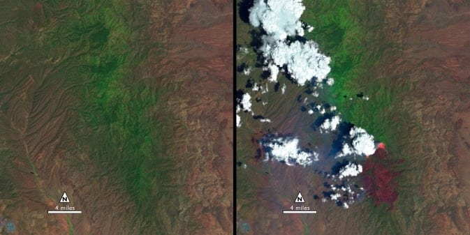
“The map looked like a big red blob,” said Penny Luehring, the U.S. Forest Service’s Burned Area Emergency Response and watershed improvement program leader, based in Albuquerque, N.M.
Red means high-severity fire, she explained – and the red areas were concentrated in a watershed drainage that fed communities west of Las Cruces, N.M. So crews got to work. The Burned Area Emergency Response, or BAER, teams are designed to go in as soon as the flames die down to help protect reservoirs, watersheds and infrastructure from post-fire floods and erosion. And Landsat satellites, built by NASA and operated by the U.S. Geological Survey, help direct the crews to those forest areas needing attention.
As a wildfire starts to die down, fire managers like Luehring can contact the Forest Service’s Remote Sensing Applications Center in Salt Lake City to request maps that identify the high, moderate and low severity burns. When that call comes in, remote sensing specialist Carl Albury finds satellite imagery of the burned forest both pre- and post-fire.
In Landsat images, he looks at two of the 11 spectral bands – the near-infrared band and a short-wave infrared band.
“The near infrared reflects well from healthy vegetation, and the short-wave infrared bands reflect well from exposed ground,” Albury said. “By comparing the normalized ratio of the near- and shortwave-infrared bands in the pre-fire image to the post-fire image, we can estimate the burn severity.”
The near-infrared wavelength bounces off of healthy plant cells, and so sends back a strong signal to the Landsat detector that isn’t present over burned areas, explained Jeff Masek, Landsat program scientist with NASA’s Goddard Space Flight Center in Greenbelt, Md. But the shortwave infrared band – added to Landsat satellites starting with Landsat 4 – has a distinct spectral signature for burned areas.
“The char will show up very clearly in the shortwave,” Masek said.
Albury takes a ratio of the two spectral bands, both before and after a fire. Comparing those ratios, he creates a rough map of fire severity, called the Burned Area Reflectance Classification, or BARC. The BAER teams calibrate or adjust the maps based on on-the-ground observations, and then use them to plan time-sensitive restoration projects.
“Without the BARC product the only way for them to assess the fire is on foot or by helicopter,” Albury said, noting that doing so is often infeasible for large fires on remote terrain. “It gives them a sense for how much they need to do, and where they need to do it.”
While he also employs remote sensing data from other satellites, Landsat is the satellite of choice, Albury said. That’s because of the coverage of its spectral bands as well as the free availability of the images – he can sort through to find cloud-free views of that forest at a similar time in the growing season for the pre-fire comparison. And with Landsat 8 online this summer, the new images don’t have the gaps present in Landsat 7 imagery. Plus, having two satellites orbiting halves the wait time for post-fire images.
The Latest Bing News on:
Landsat
- Earth observation data to drive $3 trillion in economic benefits by 2030: WEFon May 7, 2024 at 2:50 am
According to the report, the global value of EO data could swell from $266 billion to just over $700 billion in six years ...
- Rugby Provides Exploration Update on its Gold-Silver Projects in Santa Cruz Province, Argentinaon May 6, 2024 at 11:30 pm
Figure 5. Processed Landsat image showing gold geochemistry and prospect location. Venidero hosts the north-south striking gold-bearing Gorgonzola vein. Drilling has yet to be conducted. Recent ...
- Earth from space: Mysterious wave ripples across 'galaxy' of icebergs in Arctic fjordon May 6, 2024 at 12:00 am
A puzzling arc was spotted in the water of a Greenland fjord littered with iceberg fragments. There are a couple of possible explanations for this bizarre phenomenon but we will likely never know what ...
- Tulip Frenzy: Netherlands’ Colorful Spring Spectacle Captured From Spaceon May 5, 2024 at 7:40 am
In the spring of 2024, the Netherlands showcased its beautiful flower fields through satellite images, as the peak of the blooming season brought vibrant colors to the Dutch landscape. From March to ...
- NASA is helping protect tigers, jaguars, and elephants—here's howon May 3, 2024 at 10:19 am
As human populations grow, habitat loss threatens many creatures. Mapping wildlife habitat using satellites is a rapidly expanding area of ecology, and NASA satellites play a crucial role in these ...
- Thermal Infrared Remote Sensing At Yellowstone 301: Thermal Metricson April 30, 2024 at 1:53 am
Calculating important thermal metrics at Yellowstone National Park that can be used for monitoring change over time.
- NASA releases satellite photos of Dubai and Abu Dhabi before and after record floodingon April 24, 2024 at 1:20 am
The deluge closed schools and businesses, grounded hundreds of flights, and destroyed cars, businesses and other property.
- NASA’s Landsat 9 satellite captures before and after pics of Dubai floods from spaceon April 23, 2024 at 5:52 am
One of the pictures taken by NASA satellite shows flooding in Jabel Ali, while another shows flooded areas in Abu Dhabi, the capital of UAE.
- NASA Posts Pics Of Flooded UAE Areas After 6 Billion Cubic Metres Of Rainon April 22, 2024 at 12:12 am
The deluge last week hit the normal life in Dubai, where a majority of private sector entities opted for work from home.
- Unlocking clearer views of our world's water: A Landsat legacyon March 18, 2024 at 1:39 pm
By meticulously analyzing over 4.8 million Landsat images spanning from Landsat 5 through Landsat 8, they uncovered striking spatial and temporal variations in cloud-free data across the globe.
The Latest Google Headlines on:
Landsat
[google_news title=”” keyword=”Landsat” num_posts=”10″ blurb_length=”0″ show_thumb=”left”]
The Latest Bing News on:
Forest restoration
- Can Forests Be More Profitable Than Beef?on May 2, 2024 at 5:00 am
Cattle ranches have ruled the Amazon for decades. Now, new companies are selling something else: the ability of trees to lock away planet-warming carbon.
- Wildfire prevention: New BurnBot to improve forest restoration in Tahoe-Truckee regionon May 1, 2024 at 6:50 pm
Truckee region are taking action to improve wildfire prevention. “Forest health has to be our number one goal. Because if we lose the forest, we lose everything else,” said Amy Berry, the CEO of Tahoe ...
- Trail restoration work to begin this summer on Moss Lake Trail and South Lake Trail, near BWCAon May 1, 2024 at 9:01 am
Northwoods Volunteer Connection, a Tofte-based non-profit founded in 2014 with a focus on connecting volunteers with restoration and stewardship projects in the Superior National Forest, is looking ...
- They turned cattle ranches into tropical forest — then climate change hiton April 27, 2024 at 10:11 am
The problem is sometimes called the human-grass-fire cycle: when invasive grasses, often introduced through agriculture, crowd out forests and then dry out and become fuel, making the landscape more ...
- Hoosier National Forest restoration project advanceson April 26, 2024 at 4:28 pm
The U.S. Forest Service says the project will not cause harm to wildlife or water resources, and several efforts will help control erosion.
- Environmental advocates sue over Ashley National Forest Aspen Restoration Projecton April 26, 2024 at 3:06 pm
The U.S. Forest Service is facing a lawsuit over new efforts to improve aspen health in Ashley National Forest.
- Opinion: Is planting trees on Arbor Day one way we can all fight climate change? Not so muchon April 25, 2024 at 5:00 pm
The Nature study found that worldwide forest restoration could remove a staggering 226 gigatons of carbon dioxide from the atmosphere, the equivalent of approximately 20 years of global emissions ...
- South Hero community helps with forest restoration project on Earth Dayon April 23, 2024 at 7:50 am
With Earth Day taking place on Monday, the South Hero community came together to volunteer to clean up one of their local parks and restore one of its forests. About a dozen volunteers got their ...
- Want to restore a forest? Give it back to Indigenous peoples who call it homeon April 22, 2024 at 5:02 am
She wants to bring back the forest that was here before it was razed to make room for cattle. Ríos is Cabécar, one of the Indigenous peoples in Costa Rica fighting to reclaim land taken by ...
- How fruit-eating birds could help regrow tropical forestson April 15, 2024 at 9:10 am
To combat this, 12 million hectares of land are targeted for restoration and natural recovery under the Atlantic Forest Restoration Pact. New data from this study is helpful for determining how to ...
The Latest Google Headlines on:
Forest restoration
[google_news title=”” keyword=”forest restoration” num_posts=”10″ blurb_length=”0″ show_thumb=”left”]

