Has the potential to transform how tropical research is conducted
High above the Amazon rainforest in Peru, a team of scientists and technicians is conducting an ambitious experiment: a biological survey of a never-before-explored tract of remote and inaccessible cloud forest. They are doing so using an advanced system that enables them to map the three-dimensional physical structure of the forest as well as its chemical and optical properties. The scientists hope to determine not only what species may lie below but also how the ecosystem is responding to last year’s drought—the worst ever recorded in the Amazon—as well as help Peru develop a better mechanism for monitoring deforestation and degradation.
The system—conceived by Greg Asner, a scientist at the Carnegie Institution for Science—has the potential to transform how tropical research is conducted. It could also help alleviate uncertainty about carbon emissions from deforestation and different forms of forest management, both of which are critical to REDD, a U.N. program designed to compensate tropical countries for reducing deforestation and forest degradation. Finally, the system may substantially improve understanding of tropical ecosystems.
Asner did his undergraduate work as an engineer and subsequently trained in ecology and biogeochemistry. Applying his engineering acumen to biological issues, he developed the original Carnegie Airborne Observatory (CAO) in 2006 to measure key characteristics of tropical forests. The CAO is a specialized aircraft equipped with optical, chemical, and laser sensors, which together form AToMS (the Airborne Taxonomic Mapping System), enabling Asner and his team to create high-resolution, three-dimensional maps of vegetation structure and plant communities.
While satellite forest monitoring systems provide breadth of coverage, CAO offers detail. Whereas a satellite (e.g. MODIS or LandSat) might typically enable mapping in tens of meters to kilometers in resolution, CAO can capture detailed images of individual trees at a rate of 500,000 or more per minute. There are no other aircraft systems with the capabilities of CAO, although Asner is helping the National Science Foundation develop one and is in talks with NASA about equipping a satellite with the system.
“The whole idea was to measure each of the things plant ecologists measure on the ground to evaluate biodiversity,” said Asner, as we flew 7,000 feet over the Amazonian cloud forest about an hour’s flying time from Cuzco. “There was not a single technology that could measure each of the features we needed, so we decided to put together technologies that were close to doing some of those things. Along the way we developed some new technologies.”
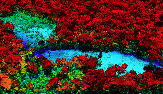
To understand tropical forest ecology, one of the most basic things scientists need to know about a landscape is the types of habitats available. CAO is equipped with a powerful LiDAR system with a pair of sweeping lasers that send 400,000 pulses per second toward the ground below. These blast through canopy vegetation, reach the forest floor, and return a wealth of information about the forest’s structure. Depending on the aircraft’s altitude, sensors can map the forest at resolutions ranging from ten centimeters to one meter,fine enough to “see” understory shrubs and epiphytes in tree crowns. LiDAR is also very good for measuring above-ground biomass, or the amount of carbon stored in a forest’s vegetation, as well as for hydrology—it can pick up surface elevations to identify watersheds and waterways.
These capabilities make LiDAR a powerful tool for mapping the habitat created by the canopy in tropical forests. The sensor has already been used by primatologists in the Amazon to see how trees branch and understand why primates select certain habitats.
But the LiDAR is only one of CAO’s strengths. To truly understand an ecosystem, scientists need to know more about its characteristics, including aspects that can’t be been by the naked eye. This is where CAO really sets itself apart—its VSWIR Imaging Spectrometer can pick up the chemical and spectral (light-reflecting) properties of individual plants thousands of feet below.
This sensor—built by engineers at NASA’s Jet Propulsion Laboratory—is the first of its kind. The spectrometer can detect dozens of signals such as photosynthetic pigment concentrations, water content of leaves, defense compounds like phenols, structural compounds such as lignin and cellulose, as well as phosphorous and other micronutrients. These signals can build signatures to distinguish individual plant species as well as other measures of forest condition. The result is a system that can map the chemical and spectral attributes of a forest that may have more than 200 species of tree in 50 hectares.
“When leaves interact with sunlight, the compounds bend, stretch, and vibrate at different patterns and rates. These different rates lead to different scattering of light,” said Asner. “The spectrometer picks up on this and we’ve been able to deduce chemicals from these signatures.”
“This is the gateway to understanding the chemistry of the system,” he said. “We can make a map of where trees are growing the fastest. The spectrometer is the breakthrough sensor.”
Bookmark this page for “3D mapping” and check back regularly as these articles update on a very frequent basis. The view is set to “news”. Try clicking on “video” and “2” for more articles.

