


Following an earthquake or another natural disaster, it is often difficult to know the position of victims under the rubble
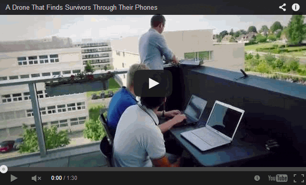
A drone makes large circles in the sky. With two powerful antennas, it sniffs the data packets emitted by mobile phones. On the ground, an interface developed specifically for this project makes it possible to track the flight of a small robotic aircraft in real time from a computer. Colored dots visible on the screen map indicate the spotted phones. The vehicle tightens its flight around the selected device to indicate its position. “In the best tests we have performed, the place indicated was within 10 meters,” says Jonathan Cheseaux who worked on this project for his master’s degree.
https://youtu.be/7ysg-m7kV14
Following an earthquake or another natural disaster, it is often difficult to know the position of victims under the rubble. At a time when most people, even in poor countries, have a mobile phone, the team of Mobile Communications Laboratory had the idea of using them to know the position of victims and thereby facilitate a search. When WiFi mode is activated, the devices emit data packets at regular intervals so that it’s possible to know various parameters, including the power received by the antenna connection. This can vary depending on the surrounding terrain, the weather or interference. It is also weaker as the layer of rubble over a person is thicker—another important factor.
But there is little similarity between these signals and a distance in meters that would make it possible to know directly the position of the device. With the drone, it is the GPS points of the captured signals from several places that locate the phone. These benchmarks are considered the center of circles which could potentially find the phone. The intersection of the latter determines the location of the phone and, therefore, probably the person. “By refining the system to automatically eliminate weaker signals, the system has become even more accurate,” explains the master’s student. “Flight tests have located a cell phone on campus with high accuracy.”
“The drone’s WiFi antenna could be replaced by Avalanche Victim Detectors (DVA) which would enable the rapid and inexpensive deployment of the first avalanche searches,” predicts the student, who is also an amateur mountaineer.
The Latest on: Rescue drones
[google_news title=”” keyword=”Rescue drones” num_posts=”10″ blurb_length=”0″ show_thumb=”left”]
via Google News
The Latest on: Rescue drones
- New leader for rescue team that covers Caithnesson April 27, 2024 at 10:00 am
A mountain rescue team that covers Caithness and Sutherland has appointed a new leader. Ben Dyson takes over from Tim Hamlet who has led the Assynt Mountain Rescue Team for the past three years. The ...
- A Chinese Firm Is America’s Favorite Drone Maker — Except in Washingtonon April 25, 2024 at 10:28 am
The drones circled over the caves and crevices scattered around the mountain trails in northern Utah, feeding real-time video back to a search team on the ground looking for a missing hiker. Nineteen ...
- Draganfly Integrates ParaZero Safety Technology into Commander 3XL Drones for Home Hospital Delivery and Emergency Responseon April 25, 2024 at 5:16 am
The integration of Draganfly and ParaZero technology is enhancing safety for UAV operations in projects such as Mass General Brigham’s Home Hospital UAV Delivery Pilot —one of the country's leading ...
- Hi-tech drones comes as a rescue to control India's malaria menaceon April 25, 2024 at 1:15 am
On World Malaria Day, experts inform that the potential application of drone technology for controlling mosquito-borne diseases like malaria is a promising prospect that could revolutionize disease ...
- Drones help Cameron Parish Sheriff’s Office with search and rescue, other operationson April 24, 2024 at 7:51 pm
Drones have become a key part of many of the Cameron Parish Sheriff’s Office’s operations, even helping them find a missing person this week.The sheriff’s office found the body of a Texas man near Mae ...
- A Chinese Firm Is America’s Favorite Drone Maker. Except in Washington.on April 24, 2024 at 5:00 pm
“In this kind of environment, that’s actually pretty quick,” said Kyle Nordfors, a volunteer search and rescue worker. He was operating one of the drones, made by the Chinese company ...
- Drones can find casualties within minutes - piloton April 24, 2024 at 6:15 am
Drones can reach people stuck on treacherous mountain terrain in minutes, while it would take a search and rescue team hours. Pilot David Champion says drones can be fitted with lights and speakers so ...
- Squamish Search & Rescue Selects Draganfly as UAV Solutions Provider, Advancing Lifesaving Operationson April 24, 2024 at 6:00 am
Draganfly Inc. (NASDAQ: DPRO) (CSE: DPRO) (FSE: 3U8A) (“Draganfly” or the “Company”), an award-winning, industry-leading drone solutions and systems developer is pleased to announce a memorandum of ...
- Squamish Search & Rescue Selects Draganfly as UAV Solutions Provider, Advancing Lifesaving Operationson April 24, 2024 at 12:00 am
This work is designed to validate the potential impact of UAV technology in critical rescue operations as SSAR moves towards operationalizing UAV use in both search and rescue settings.
- TEKEVER Unveils ARX Drone with Swarm Capabilitieson April 23, 2024 at 11:32 am
European unmanned systems manufacturer, TEKEVER, presents a new drone capable of deploying a swarm of smaller drones, set to enhance surveillance and rescue missions. At the Xponential 2024 expo, TEKE ...
via Bing News
