


New satellite imaging concept proposed by University of Leicester-led team could significantly reduce search areas for missing boats and planes
- Concept uses satellite technology already in orbit to take images of sea
- Enables ship and plane movement to be pinpointed to much more accuracy
- Data can be used when vessels are lost at sea to minimise search area and speed up search and rescue time
- Could have been used to aid search for missing Malaysian flight MH370
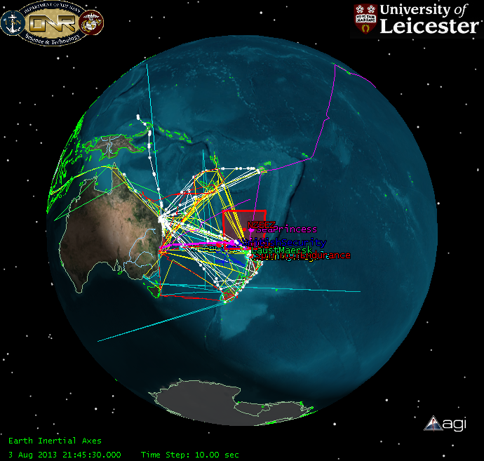
A space scientist at the University of Leicester, in collaboration with the New Zealand Defence Technology Agency and DMC International Imaging, has been trialling a concept for using satellite imagery to significantly improve the chances of locating ships and planes, such as the missing Malaysian flight MH370, lost at sea.
A preliminary study published this month in the International Journal of Remote Sensing, identified 54 satellites with 85 sensors, currently only taking images of land, which could be used to take images of the Earth’s oceans and inland waters.
The research team believe regularly updated images of the seas via these satellites could enable the reduction of search areas for missing ships to just a few hundred square miles. This offers the possibility of dramatically reducing search and rescue times and significantly improving chances of survival for missing ships.
Dr Nigel Bannister from the University’s department of Physics and Astronomy explained: “If you are in the open ocean, and you get into difficulty, particularly in a small vessel, there is a significant chance that you will be lost at sea. There is currently a big problem tracking small vessel maritime traffic and this system could provide a much improved awareness of vessel movements across the globe, using technology that already exists.
“This isn’t a surveillance system that monitors vessel movements across the oceans in real time, like radar tracking of aircraft in the sky; instead we have proposed a system which records images every time a satellite passes over specific points of the sea. If we are alerted to a lost vessel, the images allow us to pinpoint its last observed position. This could be very powerful for constraining search areas and it could reduce the time it takes to locate missing boats and planes, and hopefully their crews and passengers.”
David Neyland, former Assistant Director of the US Navy Office of Naval Research-Global, who funded the research, added: “The University of Leicester brought to this research a unique capability to build a public, open source model, of an International Virtual Constellation of spacecraft from 19 nations – a transparent view of space operations never done before.
Read more: Scientists trial system to improve safety at sea

The Latest on: Satellite imaging
[google_news title=”” keyword=”Satellite imaging” num_posts=”10″ blurb_length=”0″ show_thumb=”left”]
via Google News
The Latest on: Satellite imaging
- SDA submits satellite imagery to HCon May 8, 2024 at 5:12 pm
As the Sonamarg Development Authority (SDA) submitted the satellite imagery before the High Court, the Division Bench today made it clear that anyone seeking construction of a hotel has to demonstrate ...
- Israeli military operations in Rafah expand from airstrikes to ground operations, satellite images showon May 8, 2024 at 3:08 pm
Images obtained by CNN from Planet Labs bear a striking resemblance to the early stages of Israel’s ground invasion of Gaza in October 2023.
- Satellite imagery shows extensive flooding in Brazil as death toll nears 100on May 8, 2024 at 7:53 am
Recent floods in the Rio Grande do Sul region of southern Brazil have caused catastrophic damage and loss of life.
- RTX satellite imagers launched with Maxar’s WorldView Legionon May 8, 2024 at 7:45 am
Maxar, based in Westminster, CO, USA, provides secure, precise geospatial intelligence, enabling its government and commercial customers to monitor and navigate the Earth. From defense and ...
- NRO outlines plan to onboard commercial satellite imaging technologieson May 7, 2024 at 5:00 pm
Speaking at the GEOINT Symposium, Muend said commercial imagery is needed to complement national systems and meet the growing demands from the military and intelligence agencies for Earth observation ...
- 'Lost' satellite finally found after orbiting undetected for 25 yearson May 6, 2024 at 11:47 am
The Infra-Red Calibration Balloon (S73-7) satellite had gone off the grid from radar not once but twice — once in the 1970s and then again in the 1990s. After 25 years missing in orbit, it has finally ...
- Satellite images show Russia no longer using Crimean bridge to supply troops in Ukraineon May 6, 2024 at 9:38 am
Exclusive: After repeated Ukranian attacks on Kerch Bridge, Putin’s forces are relying on land routes through annexed eastern Ukraine to supply front lines ...
- Satellite Image Shows Construction of Egypt's New Capitalon May 4, 2024 at 3:00 am
Thirty miles from Cairo, Egypt, the new city is projected to house five million residents and become a hub for government, sports and business operations.
- Ukraine says it's cracking down on satellite images of its territory in case they give away secrets to Russiaon May 2, 2024 at 6:44 am
Satellite companies are taking images of Ukrainian territory every day, a defense official said, which risks them being used by Russia against it.
- Efforts to Restrict Satellite Image Gathering Over Ukraine by Defense Ministryon May 1, 2024 at 6:03 pm
The Ukrainian Defense Ministry is actively pursuing measures to constrain satellite imagery collection of its territory, flagging potential security risks that could aid Russian military forces. On ...
via Bing News

