


Geodesign projects are already underway nationwide
As New York, New Jersey and other states hit hard during Superstorm Sandy last fall begin their long road to recovery, the decisions they make on how to rebuild are crucial to determining how well they’re weather than next big storm. The choices range from installing large storm-surge sea barriers near Staten Island and at the mouth of New York Harbor to keep rising waters at bay, to cultivating wetlands around the southern tip of Manhattan that can provide a natural buffer.
Both concepts are on the drawing boards and are being fiercely debated on their merits. Although they are radically different, each one takes geographic design into consideration to some degree. Geodesign is an approach to city planning, land use and natural resource management that takes into account the tendency in recent years to overdevelop land at the expense of natural habitats, as well as population growth and climate change, which have left communities increasingly vulnerable to natural disasters.
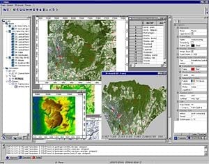
Geodesign arose thanks largely to the availability of geographic information system (GIS) data. Such data is gathered from maps, aerial photos, satellites and surveys and stored in large databases where it can be analyzed, modeled and queried. Particularly useful is data provided by the Landsat program, a joint initiative between the U.S. Geological Survey and NASA, has been placing satellites in orbit since 1972 to collect GIS data.
“With GIS, we have the tools to understand our landscape and [the] impact of our design decisions,” says Tom Fisher, dean of the University of Minnesota’s College of Design. As an analytical tool, GIS is more than geographical information—it’s a way to visualize weather, climate and demographic data as well, he adds.
Careful study of GIS data—which includes weather data but also takes into account population demographics, land use and a variety of other factors—could uncover clues about the likely intensity and impact of future storms as well as the extent to which zoning decisions can mitigate potential damage, according to Fisher, the emcee and moderator of this week’s Geodesign Summit hosted by GIS mapping software maker Esri at the company’s Redlands, Calif., headquarters. “This is an issue with Sandy—do we rebuild on the same sites, considering there could be another [major] storm within the next seven or so years? My sense is not that we lack data but that we’ve lacked the ability to visualize it and apply it to certain places,” he adds.
via Scientific American – Larry Greenemeier
The Latest Streaming News: Geodesign updated minute-by-minute
Bookmark this page and come back often
Latest NEWS
Latest VIDEO