


According to a new study, emergency responders could cut costs and save time by using near-real-time satellite data along with other decision-making tools after a flooding disaster
In the first NASA study to calculate the value of using satellite data in disaster scenarios, researchers at NASA’s Goddard Space Flight Center in Greenbelt, Maryland, calculated the time that could have been saved if ambulance drivers and other emergency responders had near-real-time information about flooded roads, using the 2011 Southeast Asian floods as a case study. Ready access to this information could have saved an average of nine minutes per emergency response and potential millions of dollars, they said.
The study is a first step in developing a model to deploy in future disasters, according to the researchers.
With lives on the line, time is money
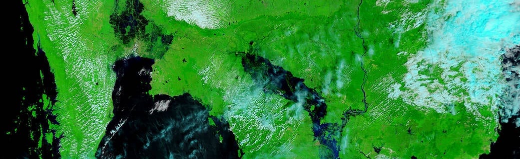
In 2011, heavy monsoon rains and La Niña conditions across Southeast Asia’s Mekong River basin inundated and destroyed millions of acres of crops, displacing millions of people and killing hundreds. NASA Goddard’s Perry Oddo and John Bolten investigated how access to near-real-time satellite data could have helped in the aftermath of the floods, focusing on the area surrounding Bangkok, Thailand.
In previous work, they helped develop an algorithm that estimated floodwater depth from space-based observations, then combined this data with information on local infrastructure, population and land cover. They used this algorithm to calculate the disaster risk for the region, considering the vulnerability and exposure for various land cover types, and mapped where the costliest damage occurred. Assessing cost of damage can help emergency managers see what areas may be most in need of resources and also aid flood-mitigation planning and develop disaster resilience. The team used this tool to support disaster recovery after the 2018 failure of the Xepian-Xe Nam Noy hydropower dam in Laos.
In the current study, the researchers investigated the value of near-real-time information on flooded roadways — specifically, how much time could have been saved by providing satellite-based flood inundation maps to emergency responders in their drive from station to destination.
Flood depth information was calculated from NASA’s Moderate Resolution Imaging Spectroradiometer (MODIS), and land cover from the NASA-USGS Landsat satellites. Infrastructure, road and population data came from NASA’s Socioeconomic Data and Applications Center (SEDAC) and OpenStreetMap, an open-access geographic data source.
“We chose data that represented what we would know within a couple hours of the event,” said Perry Oddo, an associate scientist at Goddard and the study’s lead author. “We took estimates of flood depth and damage and asked how we could apply that to route emergency response and supplies. And ultimately, we asked, what is the value of having that information?”
First, the researchers used OpenRouteService’s navigation service to chart the most direct routes between emergency dispatch sites and areas in need, without flooding information. Then they added near-real-time flooding information to the map, generating new routes that avoided the most highly flooded areas.
The direct routes contained about 10 miles’ worth of flooded roadways in their recommendations. In contrast, the routes with flood information were longer, but avoided all highly flooded areas and contained just 5 miles of affected roadways. This made the flood-aware routes about 9 minutes faster than their baseline counterparts on average.
“The response time for emergency responders is heavily dependent on the availability and fidelity of the mapped regions,” said John Bolten, associate program manager of the NASA Earth Science Water Resources Program, and the study’s second author. “Here we demonstrate the value of this map, especially for emergency responders, and assign a numeric value to it. It has a lot of value for planning future response scenarios, allowing us to move from data to decision-making.”
A 9-minute reduction in response time may seem insignificant, but previous research has pegged that value in the millions of dollars, the team said. While Oddo and Bolten did not include explicit financial calculations in their model, one previous study in Southeast Asia showed that reducing emergency vehicles’ response time by just one minute per trip over the course of a year could save up to $50 million.
Working together to save lives
The study represents a first step toward a model that can be used in future disasters, the team said.
NASA has participated in research and applications in Southeast Asia for over 15 years via several Earth Science efforts, including NASA’s Disasters, Water Resources and Capacity Building Programs. Through these efforts, NASA works with regional partners — including the Mekong River Commission (MRC), the Asian Disaster Preparedness Center (ADPC) and other agencies — to provide Earth observation data and value-added tools for local decision makers in the Mekong River basin.
Oddo and Bolten have not only developed tools for partners, but also shared their results with Southeast Asian decision makers.
“The NASA Earth Sciences Applied Sciences Program works by collaborating with partners around the world,” Bolten said. “This isn’t just research; our partner groups desperately need this information. The work we’ve laid out here demonstrates the utility of satellite observations in providing information that informs decision making, and mitigates the impact of flooding disasters, both their monetary impact and perhaps loss of life.”
Learn more: NASA Space Data Can Cut Disaster Response Times, Costs
The Latest Google Headlines on:
Near-real-time satellite data
[google_news title=”” keyword=”near-real-time satellite data” num_posts=”10″ blurb_length=”0″ show_thumb=”left”]
The Latest Bing News on:
Near-real-time satellite data
- Scaling the concerns over a woman backpacking aloneon April 28, 2024 at 4:59 am
Those schooled in outdoor safety would not endorse my approach to backpacking, as is apparent in my backcountry motto: If you're going to be stupid, you have to be tough.
- Beavers are helping fight climate change, satellite data showson April 27, 2024 at 8:00 am
Scientists at Utah's Boise State University and Utah State University are using satellite data to identify streams where once-eradicated beavers can be re-introduced to boost vegetation. They're also ...
- Best Internet Providers in Flint, Michiganon April 27, 2024 at 7:25 am
Pricing and speed data are variable: certain addresses may qualify for different ... according to our database of plan information provided directly by ISPs. At the same time, the text is specific to ...
- UofL scientists find measure for benefits of time in green natureon April 26, 2024 at 6:55 am
A new discovery at the University of Louisville may help scientists test the effects of exposure to green plants “greenness” on health. Pawel Lorkiewicz, associate professor of chemistry and ...
- Juniper Re partners with satellite company ICEYE for disaster insightson April 26, 2024 at 5:14 am
This collaboration aims to bolster Juniper Re's portfolio, enabling access to near real-time observed data on large-scale disasters such as floods and wildfires.
- How A.I. Is Revolutionizing Marine Conservationon April 25, 2024 at 5:01 am
Driven by a childhood marked by war and environmental devastation, marine scientist Dyhia Belhabib developed an innovative technology to combat illegal fishing ...
- ICEYE and Juniper Re announce flood and wildfire data collaborationon April 25, 2024 at 2:00 am
ICEYE, a provider of satellite-powered disaster management solutions, has announced a multi-year flood and wildfire data collaboration with Juniper Re, ...
- ICEYE and Juniper Re, LLC announce multi-year flood and wildfire data collaborationon April 24, 2024 at 11:18 pm
HELSINKI, April 25, 2024 /PRNewswire/ -- ICEYE, a global leader in satellite-powered disaster management solutions, has announced a new data collaboration with Juniper Re, LLC ("Juniper Re"), the ...
- CERN's edge AI data analysis techniques used to detect marine plastic pollutionon April 24, 2024 at 1:07 pm
Science X is a network of high quality websites with most complete and comprehensive daily coverage of the full sweep of science, technology, and medicine news ...
- NASA’s PACE Data Is Redefining Our View of Earth’s Climate and Oceanson April 21, 2024 at 11:51 am
NASA's new PACE satellite provides essential data on ocean health, air quality, and climate effects, enhancing scientific understanding and supporting global environmental monitoring. NASA is now ...
The Latest Google Headlines on:
Satellite data
[google_news title=”” keyword=”satellite data” num_posts=”10″ blurb_length=”0″ show_thumb=”left”]
The Latest Bing News on:
Satellite data
- Satellite spots spider-like formations on Marson April 27, 2024 at 8:43 pm
Astronauts with arachnophobia may not want to be the first humans to set foot on the Red Planet when NASA intends to launch a crew in the 2030s.Recently released satellite imagery by the European ...
- U of A set to launch student-led satellite missionon April 27, 2024 at 10:00 am
A University of Arizona student-led and built satellite will be launched into space. If the inflatable antenna works correctly, other missions will use it.
- Beavers are helping fight climate change, satellite data showson April 27, 2024 at 8:00 am
Scientists at Utah's Boise State University and Utah State University are using satellite data to identify streams where once-eradicated beavers can be re-introduced to boost vegetation. They're also ...
- New NASA satellite monitoring ocean healthon April 26, 2024 at 6:30 am
PACE will reveal how aerosols might fuel phytoplankton growth in the ocean and help identify harmful algal blooms.
- Stunning satellite images show just how big Death Valley’s lake really was. See themon April 25, 2024 at 2:07 pm
The images show the rare lake in the middle of the desert in California was deeper than previously thought, which might explain its staying power.
- Strengthening Data Security in Satellite Communications with Ajay Chandraon April 24, 2024 at 11:17 pm
Satellite communication offers vital connectivity in remote regions, but it also presents a significant challenge for ...
- Downloading Satellite Imagery With A Wi-Fi Antennaon April 24, 2024 at 4:01 pm
Over the past century or so we’ve come up with some clever ways of manipulating photons to do all kinds of interesting things. From lighting to televisions and computer screens to ...
- Satellite Applications Catapult trials Arqit Network Secure™on April 24, 2024 at 6:00 am
Arqit Quantum Inc. (Nasdaq: ARQQ, ARQQW) (Arqit), a leader in quantum-safe encryption, today announced the successful trial deployment of Arqit’s Network Secure product by the Satellite Applications ...
- Varsity To Adopt Supercomputer Cluster To Process Satellite Dataon April 22, 2024 at 11:13 pm
The management of Cosmopolitan University, Abuja is set to adopt a supercomputer cluster to process satellite data that can support agricultural practices and ...
- Bangladesh uses satellite transmitters on saltwater crocodiles in Asia’s firston April 22, 2024 at 6:00 am
In a breakthrough in saltwater crocodile conservation in the country, Bangladesh has started using a satellite tagging system to monitor the species’ movements, habits, and life span in the Sundarbans ...

