


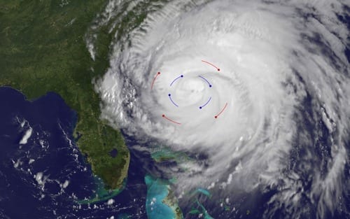
Controls engineers at UC San Diego have developed practical strategies for building and coordinating scores of sensor-laden balloons within hurricanes.
Using onboard GPS and cellphone-grade sensors, each drifting balloon becomes part of a “swarm’’ of robotic vehicles, which can periodically report, via satellite uplink, their position, the local temperature, pressure, humidity and wind velocity.
This new, comparatively low-cost sensing strategy promises to provide much-needed in situ sampling of environmental conditions for a longer range of time and from many vantage points within developing hurricanes. This has the potential to greatly improve efforts to estimate and forecast the intensity and track of future hurricanes in real time.
Current two to five day forecasts of many hurricanes deviate significantly from each other, and from the truth. For example, as Hurricane Matthew churned toward the eastern seaboard in early October of 2016, various news outlets reported “forecasts” like “Hurricane Matthew will probably make landfall somewhere between Charleston and Boston, so everyone brace yourselves.”
“Guidance like this is entirely inadequate for evacuation and emergence response preparations,” said Thomas Bewley, a professor at the Jacobs School of Engineering at UC San Diego and the paper’s senior author.
Improved forecasts, to be greatly facilitated by improved in situ environmental sampling, are essential to protect property and save lives from such extreme environmental threats, he added.
Key challenges in this effort include the design of small, robust, buoyancy-controlled balloons that won’t accumulate ice; the efficient coordination of the motion of these balloons to keep them moving within the hurricane, between an altitude of 0 and 8 kilometers (about 5 miles); and to keep them well distributed over the dynamically significant regions within the hurricane, for up to a week at a time.
Bewley and UC San Diego post-doctoral researcher Gianluca Meneghello detail various aspects of their work on this problem in the October 2016 issue of the Physical Review Fluids, building upon work they published in the proceedings of the eighth International Symposium on Stratified Flows (ISSF) in San Diego, (Sept. 1, 2016). They plan to expand on their work at the forthcoming IEEE Aerospace Conference in Big Sky, Mont. (March 6, 2017).
 |
| Typical spread of the zero- to five-day forecasts of the track of Hurricane Matthew, as performed by the major hurricane forecasting centers on (left) Oct 3, (middle) Oct 6, and (right) Oct 7, 2016. Data from http://www.emc.ncep.noaa.gov/gc_wmb/vxt/HWRF/tcall.php?selectYear=2016&selectBasin=North+Atlantic&selectStorm=MATTHEW14L |
How the model works
The model for large-scale coordination of balloon swarms within hurricanes, as discussed in the Physical Review Fluids article, uses a clever strategy to model predictive control by leveraging the cutting-edge Weather Research and Forecasting code developed by the National Center for Atmospheric Research, the National Oceanic and Atmospheric Administration and the Air Force Weather Agency (AFWA). Multiple simulations indicate the remarkable effectiveness of this approach, including a simulation based on the evolution of Hurricane Katrina as it moved across the Gulf of Mexico, as summarized in the video available at http://flowcontrol.ucsd.edu/katrina.mp4
`The key idea of our large-scale balloon coordination strategy,’’ said Bewley, “is to `go with the flow,’ commanding small vertical movements of the balloons and leveraging the strong vertical stratification of the horizontal winds within the hurricane to distribute the balloons in the desired fashion horizontally.”
Intermediate-scale and small-scale fluctuations in the violent turbulent flow of a hurricane, which are unresolved by forecasting codes like WRF, are quite substantial. The researchers’ strategy? “We simply ride out the smaller-scale fluctuations of the flow,” said Meneghello. “The smaller-scale flowfield fluctuations induce something of a random walk in the balloon motion. We model these fluctuations statistically, and respond with corrections only if a balloon deviates too far from its desired location in the formation.”
Background on the project
As summarized in their ISSF paper, the researchers’ strategy for applying such corrections, dubbed Three Level Control (and endearingly abbreviated TLC), applies a finite shift to the vertical location of the displaced balloon for a short period of time, again leveraging the strong vertical stratification of the horizontal winds to return the balloon to its nominal desired location.
A third essential ingredient of the project, summarized in the researchers’ IEEE paper, is the design of small (about 3 kg or 6.5 lbs.), robust, energetically-efficient, buoyancy-controlled balloons that can survive, without significant accumulation of ice, in the cold, wet, turbulent, electrically active environment of a hurricane. The balloons can operate effectively for up to a week at a time on a battery charge not much larger than that of a handful of iPhones. “Cellphone-grade technologies, for both environmental sensors as well as low-energy radios and microprocessors, coupled with new space-grade balloon technology developed by Thin Red Line Aerospace, are on the cusp of making this ambitious robotic sensing mission feasible,” said Bewley.
Control theory applied
In addition to robotics, Bewley’s team specializes in the field of control theory, which is the essential “hidden technology” in many engineering applications, such as cruise control and adaptive suspension systems in cars, stability augmentation systems in high-performance aircraft and adaptive noise cancellation in telecommunication. Control theory made it possible for SpaceX rockets to land on barges at sea.
Though the math and numerical methods involved are sophisticated, the fundamental principle is straightforward: sensors take measurements of the physical environment, then a computer uses these measurements in real time to coordinate appropriate responses by the system (in this case, the buoyancy of the balloons) to achieve the desired effect.
Bewley, Meneghello and colleagues are now working towards testing the balloons and algorithms designed in this study in the real world. With sensor balloon swarms and the special TLC coming out of their lab, fire and safety officials may soon have a crucial extra couple of days to move people out of harm’s way, and to prepare emergency responses, when the next Katrina or Sandy threatens.
[osd_subscribe categories=’hurricane-protection’ placeholder=’Email Address’ button_text=’Subscribe Now for any new posts on the topic “HURRICANE PROTECTION”‘]
Receive an email update when we add a new HURRICANE PROTECTION article.
The Latest on: Hurricane forecasting
[google_news title=”” keyword=”hurricane forecasting” num_posts=”10″ blurb_length=”0″ show_thumb=”left”]
via Google News
The Latest on: Hurricane forecasting
- 2024 hurricane names range from Alberto to William and even more if neededon May 1, 2024 at 10:38 am
With a super-charged Atlantic hurricane season in the forecast, it is possible that every name on the list of storms will be used this year -- and then some.
- A dangerous hurricane season is coming soon: Start to prepare now to stay safeon May 1, 2024 at 7:22 am
Will you be ready if a hurricane or other danger threatens your home and family? Depending on the type of disaster you're facing, you may need to shelter-in-place to stay safe. Other situations may ...
- Hurricane Season Is One Month Away. Here's How Things Look Right Nowon May 1, 2024 at 4:00 am
Sign up for the Morning Brief email newsletter to get weekday updates from The Weather Channel and our meteorologists.The 2024 Atlantic hurricane season is only one month away, and signs continue to ...
- Weather Forecasts Are About To Get More Accurateon May 1, 2024 at 3:39 am
The House passed a new bill which aims to enhance weather forecasting accuracy and emergency preparedness in the U.S.
- 2024 Atlantic hurricane season guide: Here’s what to know about this year’s stormson May 1, 2024 at 3:00 am
The official start of the 2024 Atlantic hurricane season is on June 1. Many forecasters have warned of an extremely active season due to an expected La Niña. In 2024, the National Hurricane Center ...
- National Hurricane Center plans more outreach in preparing for ‘extremely active’ storm seasonon April 30, 2024 at 7:00 am
The National Hurricane Center is gearing up for what might be an extremely active, even record-breaking hurricane season. To prepare, meteorologists are keeping an eye on rapid intensification and ...
- Forecast: 2024 hurricane season could be even worse than last year’son April 29, 2024 at 5:00 pm
Zeng's team has forecast that in addition to the five major hurricanes, there will be six Category 1 or 2 hurricanes. That makes a total of 11 hurricanes, while the historical annual average of ...
- 2024 Hurricane Season: Early area of low pressure not a precursor to busy seasonon April 25, 2024 at 11:37 am
A petite but persistent swirl of thunderstorms in the far-off Atlantic Ocean caught the eye of the National Hurricane Center on Wednesday, triggering a special forecast more than a month ahead of the ...
- A look at how the hurricane forecast cone will be different in 2024on April 24, 2024 at 7:48 pm
The National Hurricane Center annually updates its cyclone forecast cone, but during the 2024 season, the product may look a bit different. Jamie Rhome, deputy director of the NHC, said the goal is to ...
via Bing News