


Camera-equipped flying robots promise new insights into climate change effects on important ecosystems.
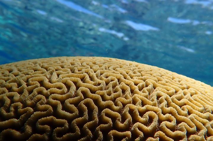
Like undiscovered groves of giant redwoods, centuries-old living corals remain unmapped and unmeasured. Scientists still know relatively little about the world’s biggest corals, where they are and how long they have lived.
The secret to unlocking these mysteries may lie with a shoebox-size flying robot.
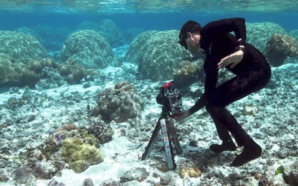
The robot in question is a four-rotor remote-controlled drone developed by Stanford aeronautics graduate student Ved Chirayath. The drone is outfitted with cameras that can film coral reefs from up to 200 feet in the air. Chirayath teamed up with Stanford Woods Institute Senior Fellow Stephen Palumbi to pioneer the use of drone technology to precisely map, measure and study shallow-water reefs off Ofu Island in American Samoa.
“Until now the challenges have been too high for flying platforms like planes, balloons and kites,” Palumbi said. “Now send in the drones.”
Chirayath, who also works as a scientist at NASA’s Ames Research Center, analyzes the drone’s footage using software he designed. The software removes distortions caused by surface wave movements and enhances resolution. To link the drone aerial footage to close-up images of corals, Chirayath and his colleagues are photographing reefs from below the water using a 360-degree camera. The result is a centimeter-scale optical aerial map and stunning gigapixel panoramic photographs of coral heads that stitch together thousands of images into one.
Surveys and maps of rainforests have resulted in new understanding of the vital role these ecosystems play in sustaining the biosphere. Detailed coral maps could do the same, allowing scientists to conduct precise species population surveys over large areas and assess the impact of climate change.
The window of time to study these mysterious ecosystems, which provide sustenance and livelihoods to a billion people, may be closing. Pollution, destructive fishing practices and climate change impacts such as warmer, more acidic ocean water threaten corals and their role as habitat for about a quarter of all ocean species.
Scientists have long endeavored to make coral reef maps. However, standard underwater approaches such as hand-drawing maps, measuring out quadrants and taking photographs are hugely time-and-labor intensive, and often inaccurate. Satellite imagery through water tends to be distorted by wave movement. Radar can’t penetrate the water’s surface, and sonar doesn’t work well in the shallow water where most corals reside. That’s where drones and Chirayath’s software come in.
When Chirayath first developed his optical software, called Fluid Lensing, NASA hired the young engineer to develop a satellite concept that would image targets such as vegetation and ocean flows on Earth, as well as targets in space. Soon, Chirayath began to think about other applications for the software. After learning about widespread coral bleaching and a lack of accurate reef maps, he dreamed up a camera-equipped drone to do the job.
“I was inspired by the way the human eye works in conjunction with the brain to try to resolve an obscured image,” Chirayath said. He compared his drone-captured coral images to sketchbook pictures of a person behind a waterfall. The person’s face would be heavily distorted in a photograph, but a patient sketch artist could draw the face clearly over time. “It’s an ability to rapidly assimilate a vast amount of data and, in effect, see through strong optical distortions.”
Word of Chirayath’s Fluid Lensing experiments in water tanks at the Monterey Bay Aquarium spread quickly to Palumbi, a professor of marine sciences and director of Stanford’s nearby Hopkins Marine Station. Palumbi invited Chirayath to join him on a research trip to Ofu.
“The lensing takes a huge problem in looking through the surface of the water and turns it into an advantage,” Palumbi said. “It not only removes the ripples but uses their magnification to enhance the image.”
Go deeper with Bing News on:
Coral research
- St. John Reef Reports gives public insight on coral health
Durgadeen is one of the four coral disease researchers who runs the St. John Reef Reports page, which launched in January 2024. “We update the public on the happenings on St. John reefs,” Durgadeen ...
- Coral Larvae Journey Far and Wide in the Western Indian Ocean
Researchers mapped coral reef connectivity across the Seychelles archipelago to inform conservation efforts in the face of climate change.
- USF incubator acceptance helps company's mission to protect coral from deadly disease
Ocean Alchemists started saving coral from a dangerous disease in 2019. The company wants to reach the next growth stage with the USF incubator program.
- A Coral-Bleaching Event is Devastating Reefs Globally: the Spiritual, Pyschological and Cultural Toll
The world’s corals have reached a grim milestone, with scientists across the world confirming the fourth global bleaching event on record. In April 2024, ...
- 'We are learning how to act as coral midwives'
The Derby team is learning how to act as coral "midwives" and grow sought-after species in labs. They are working with a team in Indonesia to develop a blueprint that could provide an income for ...
Go deeper with Google Headlines on:
Coral research
[google_news title=”” keyword=”Coral research” num_posts=”5″ blurb_length=”0″ show_thumb=”left”]
Go deeper with Bing News on:
Coral reefs
- St. John Reef Reports gives public insight on coral health
Durgadeen is one of the four coral disease researchers who runs the St. John Reef Reports page, which launched in January 2024. “We update the public on the happenings on St. John reefs,” Durgadeen ...
- Great Barrier Reef’s worst bleaching leaves giant coral graveyard: ‘It looks as if it has been carpet bombed’
Scientists stunned by scale of destruction after summer of storm surges, cyclones and floods ...
- ‘Pale’ of gloom in Lakshadweep as mass bleaching hits coral reefs
KOTTAYAM: Alarm bells are ringing in Lakshadweep as the coral reefs there are showing worrying signs of mass bleaching (coral mortality). The phenomenon, a clear indication of severe heat stress on ...
- A Coral-Bleaching Event is Devastating Reefs Globally: the Spiritual, Pyschological and Cultural Toll
The world’s corals have reached a grim milestone, with scientists across the world confirming the fourth global bleaching event on record. In April 2024, ...
- Coral canopies? Snail derbies? New money will help find solutions for South Florida's troubled reef
The Interior Department is sending $9 million to boost coral work after a decimating summer heat wave bleached two-thirds of South Florida's reef.
Go deeper with Google Headlines on:
Coral reefs
[google_news title=”” keyword=”coral reefs” num_posts=”5″ blurb_length=”0″ show_thumb=”left”]

