


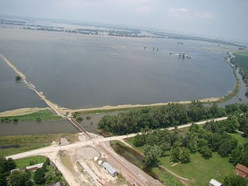
River basin storage data from on high are excellent indicators of overflow potential
Data from NASA satellites can greatly improve predictions of how likely a river basin is to overflow months before it does, according to new findings by UC Irvine. The use of such data, which capture a much fuller picture of how water is accumulating, could result in earlier flood warnings, potentially saving lives and property.
The research was published online Sunday in the journal Nature Geoscience.
A case study of the catastrophic 2011 Missouri River floods showed that factoring into hydrologic models the total water storage information from NASA’s Gravity Recovery & Climate Experiment mission – including groundwater accumulation below the surface – could have increased regional flood warning lead times from two months to as long as five months.
A review of the 2011 Columbia River floods found that warnings could have been issued three months before they occurred. Comprehensive underground measurements are not currently part of predictive models, which typically take into account river flow rates and some snowfall amounts.
“GRACE data contain important hydrologic information that is not currently being utilized to estimate regional flood potential,” said lead author J.T. Reager, who did the work as a UCI postdoctoral researcher and recently joined NASA’s Jet Propulsion Laboratory as a research scientist. “This could significantly increase flood prediction lead times within large river basins.”
The Latest on: Flood prediction
[google_news title=”” keyword=”Flood prediction” num_posts=”10″ blurb_length=”0″ show_thumb=”left”]
via Google News

The Latest on: Flood prediction
- Joe Martucci, and Eli from Margate, have your Thursday night forecaston May 9, 2024 at 2:42 pm
Eli, from Margate, helped out Meteorologist Joe Martucci with his weather forecast for Thursday night. How was his green screen debut? There's plenty of rain and coastal flooding to talk ...
- More intense rain expected as Brazilian flood death toll reaches 107on May 9, 2024 at 2:10 pm
Officials are urging those who have been rescued from the floods not to return to their homes, warning that more rain is in the forecast. From Friday to Sunday, intense rainfall is expected to hit ...
- Mother's Day Forecaston May 9, 2024 at 9:31 am
Click here to view this video from waaytv.com.
- Madison County under a flood warning until Friday afternoonon May 9, 2024 at 7:25 am
On Thursday at 7:15 a.m. a flood warning was issued by the National Weather Service valid from 10 a.m. until Friday 2:06 p.m. for Madison County.
- Severe weather brings threat of tornados, flooding again Thursday. Track forecast hereon May 9, 2024 at 6:32 am
The region is under a slight risk for severe weather, according to the weather service. Damaging straight-line winds and large hail are the primary threats. However, an isolated tornado ...
- KQ2 Forecast: Some scattered showers & storms for Thursday; Nice Friday aheadon May 9, 2024 at 6:06 am
FLOOD WARNING NOW IN EFFECT UNTIL LATE FRIDAY MORNING... * WHAT...Moderate flooding is occurring and minor flooding is forecast. * WHERE...Platte River near Agency. * WHEN...Until late Friday morning.
- First Alert Forecast: Flooding concerns continueon May 9, 2024 at 1:15 am
FLASH FLOOD WARNINGS continue across parts of the Mid State to start off the day so make sure you keep an eye out for flooded roadways across parts of the Mid State. If you encounter a flooded roadway ...
- Severe storm system brings threat of significant tornadoes, flooding to Tennessee. What to knowon May 8, 2024 at 1:23 pm
This event will also almost certainly continue to the overnight hours, presenting a nocturnal severe weather threat," read the National Weather Services forecast discussion. Tennessee, along with ...
- International SWOT mission can improve flood predictionon May 8, 2024 at 10:29 am
Rivers, lakes, and reservoirs are like our planet's arteries, carrying life-sustaining water in interconnected networks. When Earth's water cycle runs too fast, flooding can result, threatening lives ...
- Thunderstorms, Heavy Rain, Flash Flood Risks Forecast Through Thursdayon May 8, 2024 at 6:00 am
Heavy rain and thunderstorms may continue to occur across Puerto Rico and the U.S. Virgin Islands through at least Thursday. Flash flooding and mudslides are possible. The weather has led to ...
via Bing News

