


Monitoring Europe’s vast nature protection areas used to be extremely difficult. Thanks to computer algorithms developed at the Vienna University of Technology, this can now be done using aircraft and laser technology
Simply declaring a region as a nature protection area is not enough, regular monitoring of its ecological condition is also necessary. Since Nature protection areas already cover almost one fifth of the surface of the European Union, it is impossible to inspect such a vast area in the traditional way on foot. Therefore, new methods are being developed to monitor Europe’s nature protection areas from the air. Short laser pulses are sent to the ground, and information on the status of the habitat can be deduced from the reflected light signals using elaborate computer algorithms.
Laser Scanning from the Air
“The rules of the Natura 2000 network of nature protection areas request the evaluation of the conservation status of protected region at least every six years”, says Professor Norbert Pfeifer (Vienna University of Technology). “This can only be achieved with the help of remote sensing.”
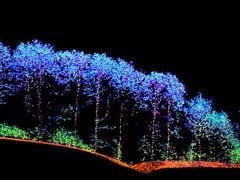
Planes fly at an altitude of 500 to 2000 metres, scanning a strip 300 to 800 metres wide. About ten points per square meter are sampled using an infrared laser pulsing half a million times a second. The pulses are reflected and return to the plane. From their travel time, the exact distance between the plane and the ground can be calculated, creating a detailed 3D map of the landscape.
Software Identifies Structure
“Our team has developed special classification software which can use this data to distinguish different types of vegetation”, says Norbert Pfeifer. Even disturbing factors such as weeds and vehicle tracks can be identified.
The 3D map obtained by the laser pulses contains much more information than a simple aerial photograph. When a forest is scanned, not all the laser light is reflected by the tree tops. The lower layers of the vegetation are surveyed as well. Ecologically healthy woodland does not only consist of various tree and shrub layers, but also of a layer of herbs and grasses. Whether or not these sub-canopy levels exist can be mathematically deduced from the infrared data.
“When people process remote sensing data for ecological monitoring, they usually focus on very specific parameters which are easy to derive”, says Norbert Pfeifer. “Our approach is quite different. We use the data to calculate precisely the same parameters as they are collected in a site inspection by human ecologists.” Therefore the data complies with EU regulations and can directly be compared to older data.
Given the power of the new method, it should be possible to go one step further. “We believe that an even better characterization of a region’s biodiversity can be obtained when we do not focus on site inspection parameters but rather try to define new parameters which are easier to obtain from above”, says Pfeifer.
Agreement Between Humans and Computer
The newly developed computer algorithms were tested in the nature protection area of Ágota-puszta, Püspökladány (Hungary), consisting of an intricate mosaic of salt meadows, loess grasslands and marsh areas. Part of the field data was used to adjust the algorithms. With the rest of the data, the method was validated. “We achieved an agreement of 80 to 90% between our data and on-site observations”, says Norbert Pfeifer. “This is a huge success. It is about the same level of agreement that would be expected if two different people assess the same region.”
Read more: Protecting Nature on the Fly

The Latest on: Monitoring Nature
[google_news title=”” keyword=”Monitoring Nature” num_posts=”10″ blurb_length=”0″ show_thumb=”left”]
via Google News
The Latest on: Monitoring Nature
- Nature lovers gather at Adams Farm for hawk watchon May 5, 2024 at 2:00 pm
ATHOL – Area raptor enthusiasts have been gathering at Adams Farm in Athol since March 11 to take part in the annual hawk watch.The team leader of the event is Mark Morris of Eastern Mass Hawk Watch, ...
- Trump Supports States Monitoring Pregnant Women to Prevent Abortionson May 4, 2024 at 10:24 am
Donald Trump’s recent remarks in a Time magazine interview have reignited debates surrounding abortion rights and state autonomy. Trump suggested that states with abortion bans should be free to ...
- Guest column: The hillsides are calling — updates on Ventura’s newest nature preserveon May 4, 2024 at 8:00 am
At Ventura Land Trust, we have been working hard to prepare Mariano Rancho for its opening in 2025. We realize it’s been a while since we shared our progress.
- Hack Your Brain to Boost Happiness by Monitoring These 4 Hormoneson May 4, 2024 at 7:00 am
You have more control over your happiness than it might seem. While you can't control everything that happens to you, you can intentionally work toward increasing the chemicals in the brain that are ...
- Denver Health develops framework to monitor psychedelic medicationson May 3, 2024 at 2:19 pm
Denver Health has recently developed a "novel framework for monitoring the health impact of psychedelic medication use." ...
- Eazeye Radiant TRLCD monitor – better than e-paper? A Reviewon May 1, 2024 at 10:22 pm
If you think only the E Ink display provides you with the best possible eye protection against digital burnout, you are in for a surprise. This new class of displays, named the RLCD, offers most of ...
- The cascading nature of tax and its effectson April 26, 2024 at 5:00 pm
One such phenomenon is the cascading nature of tax, a concept that has far-reaching implications for businesses, consumers, and the economy as a whole. At its core, the cascading nature of tax ...
- Carie Hallford, co-owner of Return to Nature Funeral Home, released from custody in Coloradoon April 25, 2024 at 5:26 pm
One of the co-owners of the Return to Nature Funeral Home that was demolished last week was released from custody on Thursday.
- 5 Attack Trends Organizations of All Sizes Should Be Monitoringon April 25, 2024 at 2:34 pm
Recent trends in breaches and attack methods offer a valuable road map to cybersecurity professionals tasked with detecting and preventing the next big thing.
- Global Cardiac Ambulatory Monitoring Industry expand at a high 5.2% CAGR and reach a startling US$ 21.6 Billion valuation by 2032 | FMIon April 25, 2024 at 6:06 am
The Global Cardiac Ambulatory Monitoring Industry is poised for a promising future, driven by rising concerns about heart health. According to a recent analysis by Future Market Insights (FMI), the ...
via Bing News

