


A new global cropland map combines multiple satellite data sources, reconciled using crowdsourced accuracy checks, to provide an improved record of total cropland extent as well as field size around the world
Knowing where agricultural land is located is crucial for regional and global food security planning, and information on field size offers valuable insight into local economic conditions. Two new global maps, released today in the journal Global Change Biology, provide a significant step forward in global cropland information on these two topics.
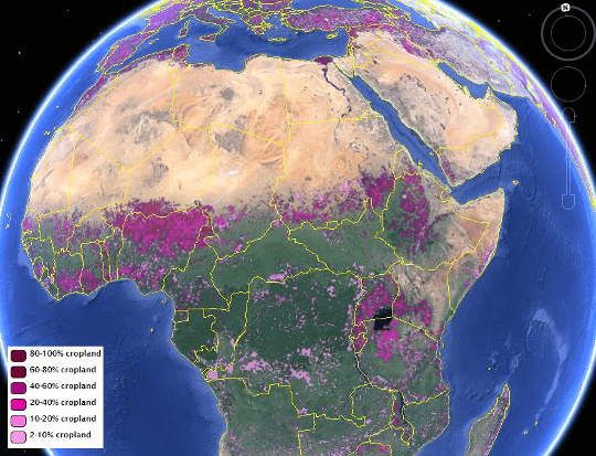
IIASA-IFPRI Global Cropland Map
The first map shows global cropland percentages at 1 kilometer resolution for the year 2005. It was developed by the International Institute for Applied Systems Analysis (IIASA) and the International Food Policy Research Institute (IFPRI) using a hybridization of multiple data sources contributed by many other institutes and organizations, combined with crowdsourcing validation data where volunteers used high-resolution data to check the accuracy of larger-scale maps.
“Current sources of information on cropland extent are not accurate enough for most applications,” says IIASA researcher Steffen Fritz, who led the project. “The global cropland map is a low cost solution to fill this need.”
IIASA researcher and co-author Linda See adds, “Our hybrid approach combines existing maps to produce a better integrated product than any of the individual global base maps currently available.”
The new global cropland map is more accurate, by virtue of increased agreement between different datasets on cropland cover. The researchers used a likelihood method to quantify the level of uncertainty, using agreement between maps to assign a likelihood to each area. See explains, “Where all maps agree there is cropland, there is a higher likelihood that cropland is present.” The map improves an earlier hybrid map first released in 2011 by IIASA.
“Getting an accurate crop map is particularly difficult in developing countries, where smallholder plots are tough to differentiate from the surrounding vegetation,” said Liangzhi You, a senior research fellow at IFPRI. “Yet cropland information is fundamental to both policymakers and donors so that they can better target their agricultural and rural development policies and investments.”
Read more: Finding farmland: New maps offer a clearer view of global agriculture
The Latest on: Global agriculture
[google_news title=”” keyword=”Global agriculture” num_posts=”10″ blurb_length=”0″ show_thumb=”left”]
via Google News
The Latest on: Global agriculture
- World Bank, ACReSAL, Others Strategise on Bridging Agricultural Data Gap from $500m Global Fundon April 26, 2024 at 7:13 pm
ACReSAL is an agency of the Federal Government supported by the World Bank having a mandate of environmental, agriculture and water resources management.
- 3 Stocks Leading the U.S. Agriculture Comebackon April 26, 2024 at 7:10 am
Every cycle in the economy brings a different set of opportunities for investors. These are weighted as a balance between risk and potential reward. Depending on market conditions, the scale may tip ...
- Agriculture Nets Market Projected to Soar to an Impressive US$ 18,242.6 Million by 2033on April 25, 2024 at 10:40 pm
The global forecast for the agriculture nets market predicts substantial growth, with a market size estimated at US$ 10,679.8 million in 2023. The anticipated Compound Annual Growth Rate (CAGR) of 5.5 ...
- This startup helps plants talk to farmers, reducing pesticides and agricultural wasteon April 25, 2024 at 10:06 am
InnerPlant’s technology uses fluorescents in the plants, so the leaves emit a signal when they are in distress.
- DJI Unveils Agras T50 and T25 Drones for Enhanced Agricultural Productivityon April 25, 2024 at 8:35 am
New Models Offer Advanced Features for Efficient Crop Management with Upgraded SmartFarm App DJI, a global leader in civilian drones and creative camera technology, today launched the Agras T50 and T2 ...
- Agricultural Adjuvant Market Poised for Growth, Anticipated to Reach US$ 6,518.4 Million by 2033on April 25, 2024 at 7:47 am
The global agricultural adjuvant market is forecast to expand at 6% CAGR over the forecast period, as per FMI’s analysis. The industry’s size is predicted to surge from US$ 3,536 million in 2023 ...
- Russia and North Korea to sign agriculture cooperation documents, says TASSon April 25, 2024 at 4:15 am
Russia and North Korea plan to sign several documents on cooperation in agriculture, the TASS news agency said on Thursday, citing the North Korean embassy in Moscow.
- K-State agricultural economics student named 39th Harry S. Truman Scholaron April 24, 2024 at 1:32 pm
MANHATTAN, Kan. (WIBW) - A Kansas State University agricultural economics student has been named the 39th Harry S. Truman Scholar. According to K-State, Adelaide Easter, senior in agricultural ...
- Dairy cattle must be tested for bird flu before moving between states, agriculture officials sayon April 24, 2024 at 12:26 pm
U.S. agriculture officials say dairy cattle moving between states must be tested for the bird flu virus in an effort to track and control the growing outbreak.
- Global Farmer - Official Reveal Traileron April 24, 2024 at 11:03 am
Check out the reveal trailer for Global Farmer, an upcoming top-down agriculture and farming strategy game where the real world is your playground. Global Farmer is coming to Steam Early Access.In ...
via Bing News
