


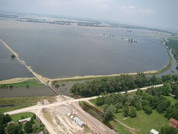
River basin storage data from on high are excellent indicators of overflow potential
Data from NASA satellites can greatly improve predictions of how likely a river basin is to overflow months before it does, according to new findings by UC Irvine. The use of such data, which capture a much fuller picture of how water is accumulating, could result in earlier flood warnings, potentially saving lives and property.
The research was published online Sunday in the journal Nature Geoscience.
A case study of the catastrophic 2011 Missouri River floods showed that factoring into hydrologic models the total water storage information from NASA’s Gravity Recovery & Climate Experiment mission – including groundwater accumulation below the surface – could have increased regional flood warning lead times from two months to as long as five months.
A review of the 2011 Columbia River floods found that warnings could have been issued three months before they occurred. Comprehensive underground measurements are not currently part of predictive models, which typically take into account river flow rates and some snowfall amounts.
“GRACE data contain important hydrologic information that is not currently being utilized to estimate regional flood potential,” said lead author J.T. Reager, who did the work as a UCI postdoctoral researcher and recently joined NASA’s Jet Propulsion Laboratory as a research scientist. “This could significantly increase flood prediction lead times within large river basins.”
The Latest on: Flood prediction
[google_news title=”” keyword=”Flood prediction” num_posts=”10″ blurb_length=”0″ show_thumb=”left”]
via Google News

The Latest on: Flood prediction
- Dustin’s First Alert Forecast: Showers and storms likely today will be worth watchingon May 18, 2024 at 6:19 am
Once we get past the severe weather threat tonight, storms will be traded for more of a steady and persistent rain for Sunday. The risk of any severe weather will be on the low end, as a few pockets ...
- Houston surveys destruction from deadly storms and races to restore power as Southeast and Gulf Coast face flood threaton May 18, 2024 at 5:39 am
As officials assess the damage from destructive storms in the Houston area that killed at least seven people and knocked out power amid rising temperatures, residents in the Southeast and Gulf Coast ...
- Final round of storms brings a widespread flood threat to the New Orleans weather forecaston May 17, 2024 at 9:49 pm
We're under a WDSU First Warning Weather Alert Day for a last round of storms that will bring a risk of widespread flooding in your New Orleans weather forecast. For an in depth analysis on the severe ...
- First Alert Forecast: Some more scattered activity possible today as flood concerns remain, looking drier for the weekendon May 17, 2024 at 10:38 am
Drier conditions will be on the way this weekend.As expected, a nice lull in the storms has moved in to start off our Friday morning which is definitely still a soggy start. That said, some scattered ...
- First Alert Forecast: Flooding conditions persist over Kauai and Oahuon May 17, 2024 at 8:02 am
This shower activity will shift towards Kauai on Friday with additional bands of showers moving over Oahu. The Kona low will begin to drift west this weekend with improving trends spreading from east ...
- First Alert Forecast: More heavy rain, more flooding possible through Fridayon May 16, 2024 at 2:12 pm
Surf along south facing shores will remain up through early next week due to overlapping, long-period advisory level swells expected. Surf along north and west facing shores will trend up Thursday, ...
- Areas to the northeast of Houston under 'high risk' for excessive rainfall, floodingon May 16, 2024 at 1:37 pm
HOUSTON — The Storm Prediction Center has issued a High Risk for excessive rainfall and flooding for areas northeast of Houston.
- Multiple rounds of storms bring threats of severe weather and flooding in your New Orleans weather forecaston May 15, 2024 at 4:43 pm
That would bring a greater threat from flooding.If all the forecast data I just showed you would happen, this is how much rain you could get.Wow! That is a TON of rain in some spots, and truthfully is ...
- ‘Nightmare scenario’ forecast calls for significant flooding in already-soaked Texas and Gulf Coast stateson May 15, 2024 at 7:52 am
Rounds of fierce storms and gushing rainfall are raising the risk of dangerous flooding late this week for millions in the already-waterlogged South.
- ‘Nightmare scenario’ forecast calls for significant flooding in already-soaked Texas and Gulf Coast stateson May 15, 2024 at 7:52 am
More rain is forecast, mainly on Thursday, for areas that have already received plenty of rain over the past month. Additional river flood impacts are expected. #txwx #txflood pic.twitter.com ...
via Bing News

